
Source: Bureau of Meteorology
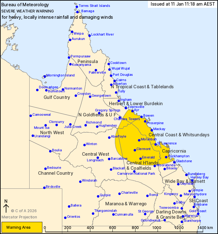
For people in Central Coast and Whitsundays and parts of Northern
Goldfields and Upper Flinders, Herbert and Lower Burdekin, Central
Highlands and Coalfields, Central West and Capricornia Forecast
Districts.
Issued at 11:18 am Sunday, 11 January 2026.
EX-TROPICAL CYCLONE KOJI HAS MADE LANDFALL, BRINGING HEAVY TO
LOCALLY INTENSE RAINFALL AND DAMAGING WINDS TODAY AND
TOMORROW.
Weather Situation: Ex-Tropical Cyclone Koji has crossed the coast
south of Ayr as a Category 1 tropical cyclone and has downgraded to
a Low. It will continue to track further southwest and inland
today, before shifting to a more westerly track over northern
Central Highlands and Coalfields district tomorrow.
DAMAGING WINDS averaging 55 to 65 km/h with wind gusts around 90
km/h are expected to continue about coastal and elevated inland
parts between Ayr and Mackay this morning. DAMAGING WIND GUSTS of
around 90 km/h are possible over inland areas south of the core of
the Low today and Monday, especially with thunderstorms.
HEAVY RAINFALL which may lead to FLASH FLOODING is likely along
coastal and adjacent inland parts between Ayr and St Lawrence
today, possibly extending south to Rockhampton into Monday.
Six-hourly rainfall totals between 80 to 150 mm are likely.
24-hourly totals between 150 to 250 mm are likely, with isolated
falls in excess of 340 mm possible. Further inland, HEAVY RAINFALL
which may lead to FLASH FLOODING is forecast to develop from this
afternoon and continue into Monday, with six-hourly rainfall totals
between 70 and 120 mm likely.
Locally INTENSE RAINFALL which may lead to DANGEROUS AND
LIFE-THREATENING FLASH FLOODING is possible about coastal and
elevated inland areas between Bowen and St Lawrence today, with
isolated six-hourly falls in excess of 250 mm possible. Locally
INTENSE RAINFALL may extend over northern parts of the Central
Highlands and Coalfields district, most likely north of Emerald,
later today and into Monday, with six-hourly falls in excess of 150
mm possible.
Conditions to persist today over southern parts of the Herbert and
Lower Burdekin, Central Coast and Whitsundays and Capricornia,
before possibly easing during Monday.
Flood Watch and Warning products are also current for large parts
of Queensland. A Severe Thunderstorm Warning will be issued if
intense rainfall is detected.
Underlying wet soils will make trees easier to fall about the
northeast tropical coast. Landslips could also occur about steep
and hilly terrain.
For all other current warnings and watches please refer to
https://www.bom.gov.au/weather-and-climate/warnings-and-alerts
Locations which may be affected include Emerald, Rockhampton,
Clermont, Mackay, Proserpine, Bowen, Moranbah, St Lawrence, Ayr,
Blackwater, Yeppoon and Collinsville.
Significant observations to 10:55 am AEST:
375 mm at Peter Faust Dam in the 24 hours to 9:00 am
327 MM AT MATTIE O NEIL BRIDGE IN THE 6 HOURS TO 10:41 AM.
180 MM AT MT WILLIAM IN THE 3 HOURS TO 10:00 AM.
179 MM AT NETHERDALE IN THE 3 HOURS TO 10:34 AM.
175 MM AT EUNGELLA IN THE 3 HOURS TO 10:31 AM.
172 MM AT UPPER FINCH HATTON CREEK THE 3 HOURS TO 10:25 AM.
165 MM AT RIDGELANDS IN THE 3 HORUS TO 10:34 AM.
162 MM AT CLARKE RANGE IN THE 3 HOURS TO 9:43 AM.
205 mm at Sennini s Road in the 6 hours to 10:47 am.
203 mm at Finch Hatton in the 6 hours to 10:43 am.
198 mm at Mt Roy in the 6 hours to 10:21 am.
185 mm at Plevna in the 6 hours to 10:53 am.
174 mm at Sandy Plateau in the 6 hours to 10:21 am.
162 mm was recorded at Koonandah in the 6 hours to 7:00 am.
159 mm at Gargett in the 6 hours to 10:52 am.
159 mm at Peter Faust Dam in the 6 hours to 8:44 am.
133 mm at Teemburra Dam in the 3 hours to 9:48 am.
132 mm at Stafford Crossing in the 3 hours to 7:24 am.
108 mm at Old Racecourse in the 3 hours to 10:00 am.
117 km/h wind gust was recorded at Hamilton Island at 8:36
am.
Sustained 64 km/h winds were recorded at Bowen Airport at 4:58
am.
Emergency services advise people to:
* If you have children make sure they are with you or an adult you
trust.
* Park your car undercover away from trees.
* Close doors and windows.
* Keep asthma medications close by. Storms and wind can trigger
asthma attacks.
* Charge mobile phones and power banks in case the power goes
out.
* Put your pets somewhere safe and make sure they can be
identified in case they get lost.
* Do not drive now unless you have to because conditions are
dangerous.
* Tell friends, family and neighbours in the area.
* Go inside a strong building now. Stay inside until the storm has
passed.
11/Jan/2026 01:40 AM


