
Source: Bureau of Meteorology
Issued at 11:01 pm EST on Thursday 19 March 2026
Headline:
Severe Tropical Cyclone Narelle to bring severe impacts to Far
North Queensland during Friday and the eastern Northern Territory
later Saturday.
Areas Affected:
Warning Zone
Cape York Peninsula between Lockhart River and Cape Tribulation,
and between Mapoon and Pormpuraaw, including Coen, Cooktown, Weipa,
and Aurukun.
Watch Zone
Northern Territory: Nhulunbuy to Port McArthur, including
Borroloola, Numbulwar, Alyangula, and Ngukurr.
Cancelled Zone
None.
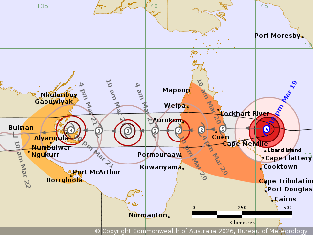
Details of Severe Tropical Cyclone Narelle 34U at 10:00 pm
AEST:
Intensity: Category 5, sustained winds near the centre of 220
kilometres per hour with wind gusts to 315 kilometres per
hour.
Location: within 30 kilometres of 13.7 degrees South 145.5 degrees
East, estimated to be 205 kilometres north of Cooktown and 250
kilometres east of Coen.
Movement: west at 20 kilometres per hour.
Severe Tropical Cyclone Narelle remains at category 5 strength is
moving westwards towards the Cape York Peninsula. Narelle is
forecast to cross the coast between Lockhart River and Cape
Melville on Friday morning as a category 5 cyclone.
Narelle is forecast to move over Cape York Peninsula as a tropical
cyclone during Friday while weakening. Narelle will then continue
to move west across the Gulf of Carpentaria, and is forecast to
strengthen again to a severe tropical cyclone before impacting the
eastern Northern Territory from late Saturday.
Hazards:
Queensland:
VERY DESTRUCTIVE WIND GUSTS in excess of 250 km/h are possible
near the centre of Severe Tropical Cyclone Narelle as it crosses
the Cape York Peninsula coast on Friday morning. VERY DESTRUCTIVE
WIND GUSTS will persist about the centre of Narelle for some
distance inland.
DESTRUCTIVE WIND GUSTS to 160 km/h are likely from Lockhart River
to Cape Flattery from tonight. DESTRUCTIVE WIND GUSTS are likely to
persist near the centre of Narelle as it moves across Cape York
Peninsula during Friday.
Gales with DAMAGING WIND GUSTS to 120 km/h are likely north of
Cooktown to north of Lockhart River and may extend south to Cape
Tribulation if Narelle takes a more southerly path. Gales with
DAMAGING WIND GUSTS to 120 km/h are also forecast to extent across
Cape York Peninsula, including areas between Mapoon and Pormpuraaw,
during Friday.
HEAVY RAINFALL which may lead to FLASH FLOODING is possible
between Cape Melville and Cape Tribulation, extending northwards
and to inland areas west of Coen during Friday. LOCALLY INTENSE
RAINFALL is likely in an area of the Peninsula bounded by Lockhart
River, Cape Flattery, Pormpuraaw, and Weipa during Friday.
Tides will be higher than normal between Coen and Cape Tribulation
as Narelle approaches and crosses the coast. LARGE WAVES may
produce MINOR FLOODING of low-lying coastal areas. There is a small
risk that tides may approach the highest tide of the year during
Friday.
Tides in Princess Charlotte Bay are likely to rise significantly
above the normal high tide, with DAMAGING WAVES and DANGEROUS
FLOODING. Any coastal residents in this area are specifically
warned of a possible DANGEROUS STORM TIDE as the cyclone centre
crosses the coast.
Once Narelle moves into the Gulf of Carpentaria, tides on the
western Peninsula between Weipa and Kowanyama may be higher than
normal. LARGE WAVES may produce MINOR FLOODING of low-lying coastal
areas.
Northern Territory:
GALES are not expected in coastal areas in the next 24 hours,
however gales are expected to develop in coastal areas between Port
McArthur and Nhulunbuy from Saturday afternoon as Narelle
approaches from the east, and extend inland to areas including
Ngukurr on Saturday night. VERY DESTRUCTIVE winds are possible near
the centre of the cyclone on Saturday night.
HEAVY RAINFALL which may lead to FLASH FLOODING is possible for
coastal and adjacent inland areas over the eastern Top End between
Port McArthur and south of Nhulunbuy from late Saturday.
Tides will be higher than normal between Nhulunbuy and Port
McArthur on Saturday and Sunday LARGE WAVES may produce MINOR
FLOODING of low-lying coastal areas.
Recommended Action:
Queensland:
People on eastern Cape York Peninsula between Lockhart River and
Cape Flattery and inland to Coen should complete preparations now
and be prepared to shelter in a safe place. People elsewhere in the
Warning zone should finalise preparations
-Boats and outside property should be secured if safe to do
so.
-IF YOUR LIFE IS IN DANGER PHONE TRIPLE ZERO (000)
IMMEDIATELY.
- Stay informed by checking your local government s Disaster
Dashboards for the latest updates.
- For cyclone preparedness and safety advice, visit the Get Ready
Queensland website www.getready.qld.gov.au
- For non-life threatening emergency assistance contact State
Emergency Services (SES) online via the SES Assistance QLD App,
Apple , Android, online www.132500.qld.gov.au, or call 132 500 from
anywhere in Queensland.
Northern Territory:
NTES advises:
People between Port MacArthur and Nhulunbuy, and inland to
Ngukurr, should consider what action they will need to take if the
cyclone threat increases.
- For cyclone preparedness and safety advice, visit the Secure NT
website at http://www.securent.nt.gov.au
- For emergency assistance call the Northern Territory Emergency
Service (NTES) on 132 500 (for assistance with storm damage, rising
flood water, fallen trees on buildings or roof damage).
Current
Tropical Cyclones
19/Mar/2026 01:10 PM

