
Source: Bureau of Meteorology
Issued at 4:41 pm EST on Wednesday 4 March 2026
Headline:
Moderate chance of a tropical cyclone developing off the North
Tropical Coast.
Areas Affected:
Warning zone: None.
Watch zone: Cooktown to Palm Island, including Port Douglas,
Cairns, Innisfail and Palm Island.
Cancelled zone: None.
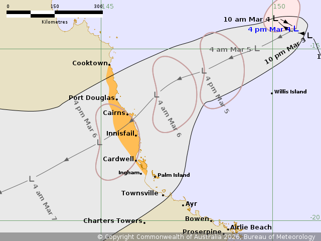
Details of Tropical Low 29U at 4:00 pm AEST:
Intensity: Tropical Low, sustained winds near the centre of 65
kilometres per hour with wind gusts to 95 kilometres per
hour.
Location: within 35 kilometres of 14.4 degrees South 150.7 degrees
East, estimated to be 600 kilometres east northeast of Cairns and
660 kilometres northeast of Cardwell.
Movement: slow moving.
Tropical Low 29U lies in the Coral Sea to the north of Willis
Island. The low has been slow moving but is expected to turn
southwest on Thursday, taking it towards the North Tropical
Coast.
There is a moderate chance of Tropical Low 29U developing into a
tropical cyclone before it makes landfall on the North Tropical
Coast during Friday.
Hazards:
GALES with wind gusts to 100 km/h are forecast to develop over
exposed coastal areas between Port Douglas and Cardwell, including
Cairns overnight Thursday or on Friday morning. Gales may extend
north to Cooktown during Friday morning, if 29U tracks further
north than forecast.
GALES with wind gusts to 100 km/h may extend further south to
coastal areas between Cardwell and Palm Island on Friday, if 29U
tracks slightly south of the forecast track.
HEAVY RAINFALL, which may lead to FLASH FLOODING, is forecast to
develop about coastal and adjacent inland areas north of Ingham on
Thursday. Heavy rainfall may extend south to Palm Island and inland
areas on Friday.
Tides are likely to be higher than normal between Port Douglas and
Ingham but are not expected to exceed the highest tide of the
year.
A Flood Watch is current for northern and far northern
catchments.
Recommended Action:
- People between Cooktown and Palm Island, including Port Douglas,
Cairns and Innisfail, stay informed by checking your local
government s Disaster Dashboards for the latest updates.
- For cyclone preparedness and safety advice, visit the Get Ready
Queensland website www.getready.qld.gov.au
- For non-life threatening emergency assistance contact State
Emergency Services (SES) online via the SES Assistance QLD App
(Apple, Android), online 132500.qld.gov.au, or call 132 500 from
anywhere in Queensland.
Current
Tropical Cyclones
04/Mar/2026 06:52 AM

