
Source: Bureau of Meteorology
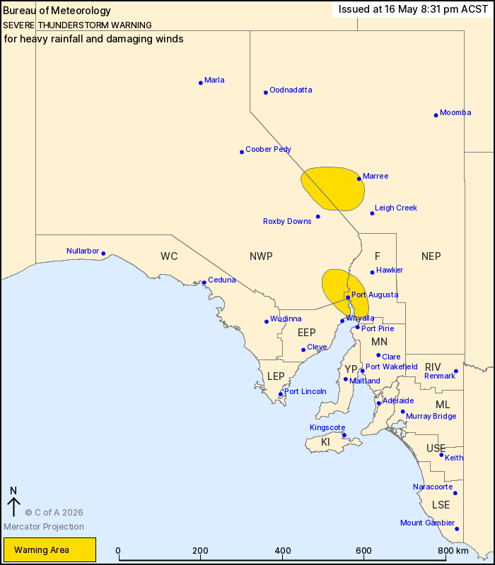
For people in parts of Eastern Eyre Peninsula, Flinders, North
West Pastoral and North East Pastoral districts.
Issued at 8:31 pm Saturday, 16 May 2026.
Severe thunderstorms in northern and central parts
Weather Situation: A trough moving east combines with an unstable
airmass to trigger severe thunderstorms in northern and central
parts of the state. These are expected to continue this evening as
they gradually move east.
Severe thunderstorms are likely to produce heavy rainfall that may
lead to flash flooding and damaging winds in the warning area over
the next several hours. Locations which may be affected include
Port Augusta, Marree, Melrose and Quorn.
Severe thunderstorms are no longer occurring in the Adelaide
Metropolitan and Mount Lofty Ranges districts and the warning for
these districts is CANCELLED.
37.2 MM WAS RECORDED AT WOOMERA IN THE 30 MINUTES TO 5:30
PM.
28 mm was recorded at Glenelg in the 30 minutes to 8:00 pm.
27.8 mm was recorded at Patawalonga Lake in the 30 minutes to 8:00
pm.
24.6 mm was recorded at Adelaide Airport in the 30 minutes to 8:00
pm.
98 km/h wind gust was recorded at Woomera at 5:35 pm
The State Emergency Service advises that people should:
* Secure or put away loose items around your property.
* Move cars under cover or away from trees.
* Keep clear of fallen power lines.
* Don't drive, ride or walk through flood water.
* Keep clear of creeks and storm drains.
* Stay indoors, away from windows, while storms are nearby.
16/May/2026 11:06 AM

