
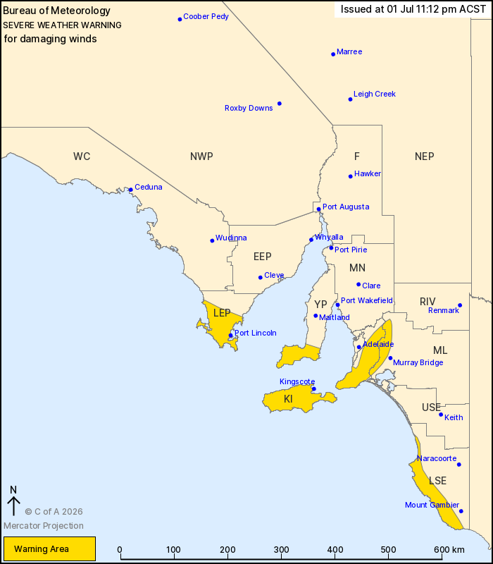
Source: Bureau of Meteorology
For people in Mount Lofty Ranges, Kangaroo Island and parts of
Lower Eyre Peninsula, Yorke Peninsula, Murraylands and Lower South
East districts.
Issued at 11:12 pm Wednesday, 1 July 2026.
Damaging winds possible over exposed coastal areas during Thursday
and early Friday
Weather Situation: a trough is forecast to graze the south of the
state overnight tonight, with a deep low pressure system expected
to pass to the south later on Thursday.
DAMAGING WINDS GUSTS of around 90 km/h are possible with showers
from around midnight tonight over parts of the Lower Eyre
Peninsula, Yorke and Fleurieu Peninsulas, over and just to the east
of the Mount Lofty Ranges, Kangaroo Island, and coastal parts of
the Lower South East. These winds will ease during Thursday
morning.
DAMAGING SOUTHWESTERLY WINDS averaging 50-65 km/h with peak gusts
of around 100 km/h are likely over the Lower South East coast
during Thursday evening, easing later on Friday morning.
Locations which may be affected include Port Lincoln, Kingscote,
Victor Harbor, Warooka, Robe and Millicent.
The State Emergency Service advises that people should:
* Move vehicles under cover or away from trees;
* Secure or put away loose items around your property.
* Stay indoors, away from windows, while conditions are
severe.
01/Jul/2026 01:49 PM

