
Source: Bureau of Meteorology
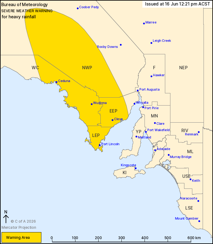
For people in Lower Eyre Peninsula, Eastern Eyre Peninsula and
parts of West Coast and North West Pastoral districts.
Issued at 12:21 pm Tuesday, 16 June 2026.
Heavy rainfall developing from Wednesday morning with the passage
of a cold front.
Weather Situation: A low crossing the Great Australian Bight will
extend a cold front over western parts of the state from early
Wednesday morning, before shifting to central parts by the evening.
Northwesterly winds ahead of the front are bringing increased
moisture and rainfall to the area, with lines of heavy showers and
thunderstorms expected to produce areas of heavy rainfall.
HEAVY RAINFALL which may lead to FLASH FLOODING is possible for
the North West Pastoral from early Wednesday morning, extending to
the West Coast later in the morning and the Eyre Peninsula by the
afternoon. Six-hour rainfall totals between 30 to 45 mm are
possible, with localised falls up to 60 mm.
Rainfall is forecast to ease below warning thresholds by late
Wednesday evening.
Locations which may be affected include Port Lincoln, Ceduna,
Wudinna, Cleve, Elliston, Tarcoola, Streaky Bay, Cummins, Tumby Bay
and Kimba.
The State Emergency Service advises that people should:
* Don't drive, ride or walk through flood water;
* Keep clear of creeks and storm drains;
* Stay indoors, away from windows, while conditions are
severe.
16/Jun/2026 02:59 AM

