
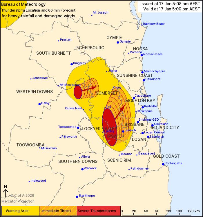
Source: Bureau of Meteorology
For people in Ipswich and parts of Somerset, Scenic Rim, South
Burnett, Toowoomba, Lockyer Valley, Brisbane City and Moreton Bay
Council Areas.
Issued at 5:08 pm Saturday, 17 January 2026.
The Bureau of Meteorology warns that, at 5:00 pm, severe
thunderstorms likely to produce heavy rainfall that may lead to
flash flooding and damaging winds were detected near the area south
of Esk and the area north of Crows Nest. These thunderstorms are
moving towards the east to northeast. They are forecast to affect
Ipswich and Harrisville by 5:30 pm and Peak Crossing and Redbank
Plains by 6:00 pm.
44 mm of rainfall was recorded at Upper Western Creek in the 30
minutes to 4:52 pm.
55 mm of rainfall was recorded at Forest Hill in the 30 minutes to
4:49 pm.
53 mm of rainfall was recorded at Adam's Bridge (Bremer River,
west of Harrisville) in the 30 minutes to 4:44 pm.
53 mm of rainfall was recorded at McGarrigal Road (south of
Laidley) in the 30 minutes to 4:30 pm.
60 mm of rainfall was recorded at Mulgowie Road (south of Laidley)
in the 30 minutes to 4:27 pm.
48 mm of rainfall was recorded at Mt Berryman Road (south of
Laidley) in the 30 minutes to 4:25 pm.
49 mm of rainfall was recorded at Campbells Gully (Warwick) in the
30 minutes to 3:01 pm, 65 mm in the 1 hour to 3:32 pm.
Emergency services advise people to:
* Park your car undercover away from trees.
* Close doors and windows.
* Keep asthma medications close by. Storms and wind can trigger
asthma attacks.
* Charge mobile phones and power banks in case the power goes
out.
* Put your pets somewhere safe and make sure they can be
identified in case they get lost.
* Do not drive now unless you have to because conditions are
dangerous.
* Tell friends, family and neighbours in the area.
* Go inside a strong building now. Stay inside until the storm has
passed.
17/Jan/2026 07:12 AM

