
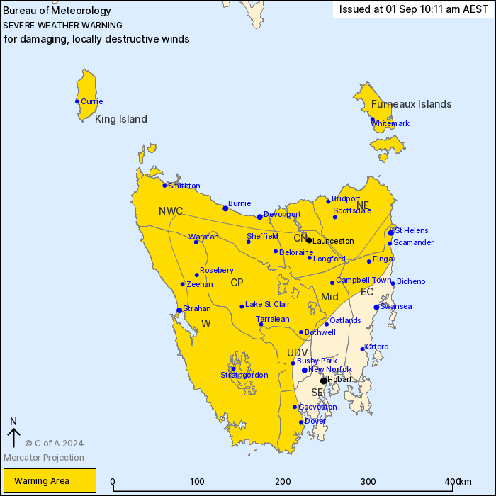
Source: Bureau of Meteorology
For people in King Island, Furneaux Islands, Western, Upper
Derwent Valley, North East, North West Coast, Central North,
Central Plateau and parts of South East, East Coast and Midlands
Forecast Districts.
Issued at 10:11 am Sunday, 1 September 2024.
Damaging winds remain possible today with DESTRUCTIVE WINDS
REDEVELOPING IN THE NORTH AND WEST THIS EVENING.
Weather situation: A vigorous west to northwesterly airstream
persists over Tasmania. Conditions have improved in the past few
hours, although bands of showers and thunderstorms today continue
to pose a risk of damaging wind gusts for most of the state.
Another strong cold front, slightly weaker than the front on
Saturday, will cross the state this evening and into early Monday
morning, mainly impacting the western and northern coasts.
DAMAGING WEST TO NORTHWESTERLY WINDS averaging 60 to 70 km/h with
peak gusts of around 110 km/h are likely to continue today about
coastal areas and elevated terrain in western and northern parts of
Tasmania but have eased in the southeast, including Hobart.
DAMAGING WINDS become more likely in the north this evening as the
next front crosses the state.
LOCALLY DESTRUCTIVE WIND GUSTS in excess of 125 km/h are likely
from this evening with showers and thunderstorms for the north
coast and elevated terrain, possibly extending down the west coast
as far south as Strahan.
DESTRUCTIVE WIND GUSTS are expected to ease from early Monday
morning, with DAMAGING WINDS possibly persisting until Monday
afternoon for the exposed west coast.
A Coastal Hazard Warning is also current for parts of the western
and northern coastlines, as well as for parts of the King Island
and Furneaux Islands coastlines. Please refer to
http://www.bom.gov.au/tas/warnings/
Locations which may be affected include Devonport, Burnie,
Launceston, St Helens, Strahan and Dover.
Significant wind gusts recorded since midnight include:
139 KM/H WIND GUST WAS RECORDED AT KUNANYI/MT WELLINGTON AT
12:01am
132 KM/H WIND GUST WAS RECORDED AT MOUNT READ AT 4:13am
124 KM/H WIND GUST WAS RECORDED AT HARTZ MOUNTAIN 12:34am
120 km/h wind gust was recorded at Scotts Peak at 6:26am
109 km/h wind gust was recorded at Low Rocky Point at 3:58am
107 km/h wind gust was recorded at Warra at 1:08am
104 km/h wind gust was recorded at Low Head at 12:11am
100 km/h wind gust was recorded at Cape Sorell at 12:07am
The State Emergency Service advises that people should:
* Supervise children closely.
* Check that family and neighbours are aware of warnings.
* Manage pets and livestock.
* Secure outdoor items including furniture and play
equipment.
* Be prepared in case of power outages and report any outages to
TasNetworks on 132 004.
* Beware of damaged trees and power lines and take care when
driving.
* Listen to the ABC radio or check www.ses.tas.gov.au for further
advice.
* For emergency assistance contact the SES on 132500.
01/Sep/2024 12:30 AM


