
Source: Bureau of Meteorology
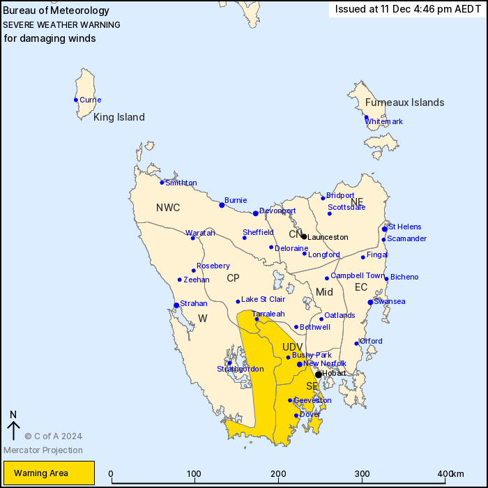
For people in Upper Derwent Valley and parts of Western, South
East and Central Plateau Forecast Districts.
Issued at 4:46 pm Wednesday, 11 December 2024.
Damaging wind gusts over southern parts of Tasmania during
Wednesday afternoon and evening.
Weather Situation: A cold front extending from a deep low pressure
system south of Tasmania will cross the state late Wednesday
evening. Vigorous westerly winds will bring damaging wind gusts to
parts of southern Tasmania during Wednesday afternoon and early
evening, before winds will slowly ease again late Wednesday
evening.
Strong westerly winds averaging 50 to 60 km/h with DAMAGING WIND
GUSTS of around 100 km/h are likely over parts of the Western,
Upper Derwent Valley, South East and Central Plateau Districts from
early Wednesday afternoon.
DAMAGING WIND GUSTS in excess of 110 km/h are possible about the
Huon Valley, Far South and exposed peaks within the warning
area.
Winds are expected to ease below thresholds late Wednesday
evening.
Locations which may be affected include New Norfolk, kunanyi/Mt
Wellington, Tarraleah, Bushy Park, Geeveston, Dover and
Huonville.
Significant wind observations to 4:30pm ADST Wednesday
include:
126 km/h wind gust was recorded at kunanyi/Mt Wellington at
1:21pm
117 km/h wind gust was recorded at Hartz Mountains at 3:25pm
106 km/h wind gust was recorded at Scotts Peak at 2:01pm
106 km/h wind gust was recorded at Warra at 2:40pm
The State Emergency Service advises that people should:
* Supervise children closely.
* Check that family and neighbours are aware of warnings.
* Manage pets and livestock.
* Secure outdoor items including furniture and play
equipment.
* Be prepared in case of power outages and report any outages to
TasNetworks on 132 004.
* Beware of damaged trees and power lines and take care when
driving.
* Listen to the ABC radio or check www.ses.tas.gov.au for further
advice.
* For emergency assistance contact the SES on 132500.
11/Dec/2024 05:52 AM

