
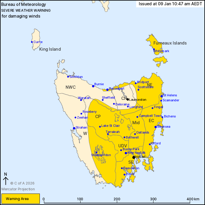
Source: Bureau of Meteorology
For people in Furneaux Islands, Upper Derwent Valley, South East,
North East, East Coast, Central Plateau, Midlands and parts of
Western, North West Coast and Central North Forecast
Districts.
Issued at 10:47 am Friday, 9 January 2026.
Damaging winds developing through much of Tasmania on Saturday
morning.
Weather Situation: A low pressure system will approach
southwestern Tasmania early Saturday morning, extending a vigorous
west to northwesterly flow across the state. A thermal trough will
cross during the day, shifting winds southwesterly and gradually
easing into the late afternoon and evening.
For northeastern Tasmania and the Furneaux Islands: DAMAGING WINDS
averaging 55 to 65 km/h with peak gusts around 100 km/h are
expected to develop around mid-morning.
For the remainder including HOBART: Strong winds averaging 50 to
60 km/h with peak gusts around 100 km/h are possible from the late
morning. DAMAGING WIND GUSTS to 120 km/h are possible about
elevated and exposed regions.
Winds are expected to ease below warning thresholds by early
Saturday evening.
Locations which may be affected include Devonport, St Helens,
Swansea, New Norfolk, Hobart and Oatlands.
The State Emergency Service advises that people should:
* Supervise children closely.
* Check that family and neighbours are aware of warnings.
* Manage pets and livestock.
* Secure outdoor items including furniture and play
equipment.
* Be prepared in case of power outages and report any outages to
TasNetworks on 132 004.
* Beware of damaged trees and power lines and take care when
driving.
* Listen to the ABC radio or check www.ses.tas.gov.au for further
advice.
* For emergency assistance contact the SES on 132500.
09/Jan/2026 12:03 AM


