
Source: Bureau of Meteorology
Issued at 10:58 am EDT on Tuesday 3 October 2023
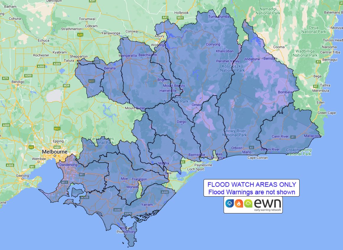
Flood Watch Number: 3
MINOR TO MODERATE FLOODING LIKELY FROM LATE TUESDAY INTO WEDNESDAY
WITH ISOLATED MAJOR FLOODING POSSIBLE FROM WEDNESDAY
A cold front is forecast to cross Victoria during Tuesday, with a
low pressure system then developing over eastern Victoria on
Wednesday. The low is forecast to move over the Tasman Sea on
Thursday.
Catchments across Victoria have been drying out over the last few
months. Catchments in East Gippsland are generally dry. Lower parts
of catchments in West Gippsland, eastern Central and North East are
dry, although some elevated areas in these catchments remain
wet.
Rain is forecast over central and eastern districts with some
moderate to heavy falls developing over the eastern ranges during
Tuesday into Wednesday. Rain in central and eastern parts is
expected to continue during Wednesday before easing during
Thursday.
Minor to moderate flooding is likely to develop across eastern
Victoria from late Tuesday into Wednesday. Isolated major flooding
is possible in some North East and Gippsland catchments from
Wednesday.
Catchments likely to be affected include:
Bemm, Cann and Genoa Rivers
Snowy River
Tambo River
Mitchell River
Avon River
Macalister River
Thomson River
Latrobe River
South Gippsland Rivers
Bunyip River and Dandenong Creek
Yarra River to Coldstream
Upper Murray and Mitta Mitta Rivers
Kiewa River
Ovens and King Rivers
Broken River
Seven and Castle Creeks
The Bureau of Meteorology is continuing to monitor the situation
and will issue catchment specific warnings as required.
See www.bom.gov.au/vic/warnings to view the current warnings for
Victoria.
For more information on the Flood Watch Service:
http://www.bom.gov.au/water/floods/floodWarningServices.shtml
Flood Safety Advice:
Note: This Flood Watch means that people living or working along
rivers and streams must monitor the latest weather forecasts and
warnings and be ready to move to higher ground should flooding
develop.
SES advises that all community members should:
Never walk, ride or drive through floodwater, Never allow children
to play in floodwater, Stay away from waterways and stormwater
drains during and after heavy rain, Keep well clear of fallen power
lines Be aware that in fire affected areas, rainfall run-off into
waterways may contain debris such as ash, soil, trees and rocks,
and heavy rainfall increases the potential for landslides and
debris across roads.
Current Emergency Information is available at
http://emergency.vic.gov.au For emergency assistance contact the
SES on 132 500.
Current Road and Traffic Information is available at the VicRoads
website:
http://traffic.vicroads.vic.gov.au/
Weather Forecast:
For the latest weather forecast see
http://www.bom.gov.au/vic/forecasts/
River Height and Rainfall information are available on the Bureau
of Meteorology web site at http://www.bom.gov.au/vic/flood/
Flood Warnings and Flood Watches for Victorian Catchments are also
available on: Telephone Weather Service No. 1300 659217.
Rainfall and River
Conditions Map
03/Oct/2023 12:18 AM


