
Source: Bureau of Meteorology
Issued at 2:03 pm EDT on Sunday 7 January 2024
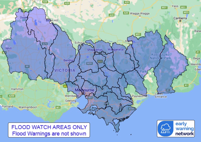
Flood Watch Number: 3
WIDESPREAD MINOR FLOODING WITH ISOLATED MODERATE FLOODING IS
LIKELY TO DEVELOP FROM MONDAY MORNING FOR PARTS OF THE FLOOD WATCH
AREA
An embedded low pressure system is developing over far western
Victoria on Sunday evening and will move eastwards across the State
into Monday. This will bring widespread rainfall in the Flood Watch
area and is likely to cause minor flooding, with isolated moderate
flooding from Monday morning.
Catchments are moderately wet following recent rainfall.
Widespread rainfall totals of 30 to 60 mm are likely in the
western and central and Gippsland catchments of Flood Watch area on
Sunday into Monday. Isolated totals of 60 to 80 mm are possible due
to heavy falls from thunderstorms.
Widespread rainfall totals of 60 to 100 mm are likely across north
central and north eastern catchments of the Flood Watch area from
late Sunday into Monday. Isolated totals over 100 mm are possible
due to heavy falls from thunderstorms.
Rainfall will ease and showers are expected to gradually contract
to the east of the state during Tuesday.
River level rises and widespread minor flooding with isolated
moderate flooding is likely to develop from Monday morning for
parts of the Flood Watch catchments.
Catchments likely to be affected include:
Snowy River
Mitchell River
Macalister River
Thomson River
Latrobe River
Traralgon Creek
South Gippsland Rivers
Bunyip River and Dandenong Creek
Yarra River to Coldstream
Yarra River downstream of Coldstream
Maribyrnong River
Werribee River
Upper Murray and Mitta Mitta Rivers
Kiewa River
Ovens and King Rivers
Broken River
Broken Creek
Seven and Castle Creeks
Goulburn River upstream of Lake Eildon
Goulburn River Eildon to Seymour
Goulburn River downstream of Seymour
Campaspe River
Loddon River
Avoca River(Minor Warning Current)
Wimmera River
A Flood Warning is current for the Avoca catchment.
The Bureau of Meteorology is continuing to monitor the situation
and will issue catchment specific warnings as required.
See www.bom.gov.au/vic/warnings to view the current warnings for
Victoria.
For more information on the Flood Watch Service:
http://www.bom.gov.au/water/floods/floodWarningServices.shtml
Flood Safety Advice:
Note: This Flood Watch means that people living or working along
rivers and streams must monitor the latest weather forecasts and
warnings and be ready to move to higher ground should flooding
develop.
SES advises that all community members should:
Never walk, ride or drive through floodwater, Never allow children
to play in floodwater, Stay away from waterways and stormwater
drains during and after heavy rain, Keep well clear of fallen power
lines Be aware that in fire affected areas, rainfall run-off into
waterways may contain debris such as ash, soil, trees and rocks,
and heavy rainfall increases the potential for landslides and
debris across roads.
Current Emergency Information is available at
http://emergency.vic.gov.au For emergency assistance contact the
SES on 132 500.
Current Road and Traffic Information is available at the VicRoads
website:
http://traffic.vicroads.vic.gov.au/
Weather Forecast:
For the latest weather forecast see
http://www.bom.gov.au/vic/forecasts/
River Height and Rainfall information are available on the Bureau
of Meteorology web site at http://www.bom.gov.au/vic/flood/
Flood Warnings and Flood Watches for Victorian Catchments are also
available on: Telephone Weather Service No. 1300 659217.
Rainfall and River
Conditions Map

07/Jan/2024 03:31 AM


