
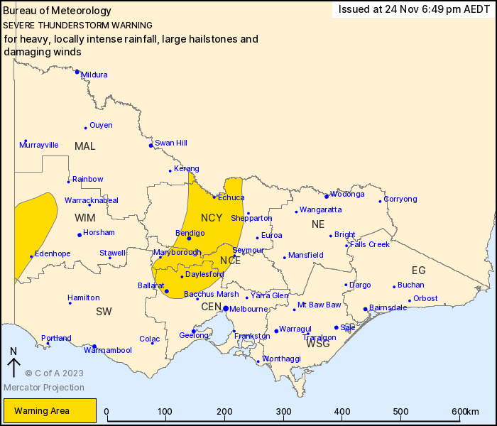
Source: Bureau of Meteorology
For people in parts of Central, Northern Country, North Central,
Wimmera, Mallee and South West Forecast Districts.
Issued at 6:49 pm Friday, 24 November 2023.
Severe thunderstorms possible through northern and western
Victoria, LOCALLY INTENSE RAINFALL in the Wimmera.
Weather Situation: A strong upper disturbance centred to the west
of Victoria is driving thunderstorm activity, with severe
thunderstorms possible.
Severe thunderstorms are likely to produce heavy, locally intense
rainfall that may lead to dangerous and life-threatening flash
flooding and large hailstones over the next several hours in parts
of the Wimmera and South West districts. Locations which may be
affected include Edenhope, Nhill and Kaniva.
Severe thunderstorms are likely to produce heavy rainfall that may
lead to flash flooding, large hailstones and damaging winds over
the next several hours in parts of the Central, Northern Country,
North Central, Mallee and South West districts. Locations which may
be affected include Bendigo, Echuca, Maryborough, Castlemaine,
Kyneton and Ballarat.
Observations to 7:00pm include:
65.2mm in 6 hours at Pigick Comparison
59.6mm in 6 hours at Mcneils Bridge
54.2mm in 6 hours at Kanagulk AWS
50.8mm in 6 hours at Hillview NYPO
47.6mm in 6 hours at Kaniva
46.0mm in 6 hours at Nhill
The State Emergency Service advises that people should:
* If driving conditions are dangerous, safely pull over away from
trees, drains, low-lying areas and floodwater. Avoid travel if
possible.
* Stay safe by avoiding dangerous hazards, such as floodwater,
mud, debris, damaged roads and fallen trees.
* Be aware - heat, fire or recent storms may make trees unstable
and more likely to fall when it's windy or wet.
* Check that loose items, such as outdoor settings, umbrellas and
trampolines are safely secured. Move vehicles under cover or away
from trees.
* Stay indoors and away from windows.
* If outdoors, move to a safe place indoors. Stay away from trees,
drains, gutters, creeks and waterways.
* Stay away from fallen powerlines - always assume they are
live.
* Be aware that in fire affected areas, rainfall run-off into
waterways may contain debris such as ash, soil, trees and rocks.
Heavy rainfall may also increase the potential for landslides and
debris across roads.
* Stay informed: Monitor weather warnings, forecasts and river
levels at the Bureau of Meteorology website, and warnings through
VicEmergency website/app/hotline.
24/Nov/2023 07:56 AM

