
Source: Bureau of Meteorology
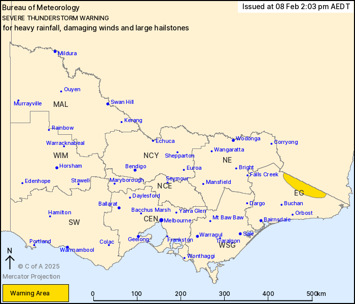
For people in parts of East Gippsland Forecast District.
Issued at 2:03 pm Saturday, 8 February 2025.
Severe thunderstorms developing near the New South Wales
border.
Weather Situation: A trough of low pressure combines with an
approaching upper-level disturbance to generate thunderstorms over
the northeast of the state this afternoon.
Severe thunderstorms are likely to produce heavy rainfall that may
lead to flash flooding, damaging wind gusts and possible large
hailstones in the warning area over the next several hours.
Locations which may be affected include Chandlers Creek and
Bonang.
The State Emergency Service advises that people should:
* If driving conditions are dangerous, safely pull over away from
trees, drains, low-lying areas and floodwater. Avoid travel if
possible.
* Stay safe by avoiding dangerous hazards, such as floodwater,
mud, debris, damaged roads and fallen trees.
* Be aware - heat, fire or recent storms may make trees unstable
and more likely to fall when it's windy or wet.
* Check that loose items, such as outdoor settings, umbrellas and
trampolines are safely secured. Move vehicles under cover or away
from trees.
* Stay indoors and away from windows.
* If outdoors, move to a safe place indoors. Stay away from trees,
drains, gutters, creeks and waterways.
* Stay away from fallen powerlines - always assume they are
live.
* Be aware that in fire affected areas, rainfall run-off into
waterways may contain debris such as ash, soil, trees and rocks.
Heavy rainfall may also increase the potential for landslides and
debris across roads.
* Stay informed: Monitor weather warnings, forecasts and river
levels at the Bureau of Meteorology website, and warnings through
VicEmergency website/app/hotline.
08/Feb/2025 03:15 AM

