
Source: Bureau of Meteorology
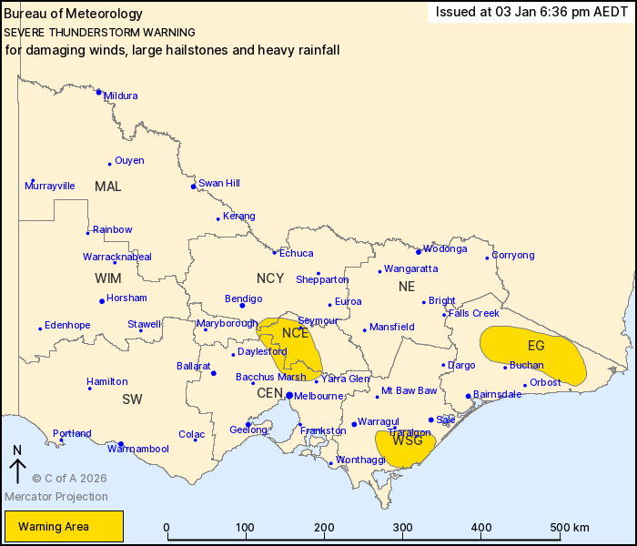
For people in parts of Central, East Gippsland, North Central,
West and South Gippsland and Northern Country Forecast
Districts.
Issued at 6:36 pm Saturday, 3 January 2026.
Severe storms continue in Gippsland, but will ease in over the
coming hours into the evening.
Weather Situation: A moist and unstable airmass is producing
severe thunderstorms through parts of Gippsland, which are slowly
moving to the east and southeast, before an easing trend is
expected during the evening.
Severe thunderstorms are likely to produce damaging winds, large
hailstones and heavy rainfall that may lead to flash flooding in
the warning area over the next several hours. Locations which may
be affected include Seymour, Yarram, Cann River, Chandlers Creek,
Combienbar and Gelantipy.
2cm hail was observed at Rawson at approximately 4:00 pm.
The State Emergency Service advises that people should:
* If driving conditions are dangerous, safely pull over away from
trees, drains, low-lying areas and floodwater. Avoid travel if
possible.
* Stay safe by avoiding dangerous hazards, such as floodwater,
mud, debris, damaged roads and fallen trees.
* Be aware - heat, fire or recent storms may make trees unstable
and more likely to fall when it's windy or wet.
* Check that loose items, such as outdoor settings, umbrellas and
trampolines are safely secured. Move vehicles under cover or away
from trees.
* Stay indoors and away from windows.
* If outdoors, move to a safe place indoors. Stay away from trees,
drains, gutters, creeks and waterways.
* Stay away from fallen powerlines - always assume they are
live.
* Be aware that in fire affected areas, rainfall run-off into
waterways may contain debris such as ash, soil, trees and rocks.
Heavy rainfall may also increase the potential for landslides and
debris across roads.
* Stay informed: Monitor weather warnings, forecasts and river
levels at the Bureau of Meteorology website, and warnings through
VicEmergency website/app/hotline.
03/Jan/2026 07:42 AM


