
Source: Bureau of Meteorology
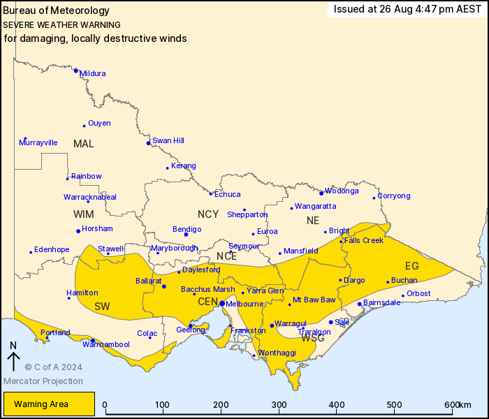
For people in Central, East Gippsland, West and South Gippsland
and parts of South West, North Central, North East and Wimmera
Forecast Districts.
Issued at 4:47 pm Monday, 26 August 2024.
DAMAGING TO LOCALLY DESTRUCTIVE WINDS DEVELOPING FROM TUESDAY
MORNING
Weather Situation: A deep, complex low-pressure system well to the
south extends a cold front which will approach Victoria later
Tuesday and cross the State early Wednesday. This, combined with a
persistent belt of high pressure across central Australia will
result in a strengthening northwesterly gradient across the State
during Tuesday. A vigorous westerly airstream will extend across
the State with and following the front on Wednesday.
DAMAGING WINDS, averaging 50 to 60km/h with gusts to around 90 to
100km/h are expected to develop during TUESDAY MORNING over central
and western elevated parts of the warning area including the Otways
and Grampians as well as eastern Alpine peaks.
Winds further strengthening during TUESDAY AFTERNOON to average 60
to 70km/h with gusts to 100km/h over all elevated parts of the
warning area and possibly extending southwards to adjacent lower
elevations including parts of the outer northwestern suburbs of
Melbourne in the afternoon, but more likely OVERNIGHT TUESDAY
including the risk across many bayside suburbs.
DESTRUCTIVE WINDS, averaging around 65 to 80 km/h with gusts up to
130km/h are possible over Alpine peaks OVERNIGHT TUESDAY with gusts
up to 110km/h across remaining areas above 1000m over eastern
Victoria.
DAMAGING WINDS averaging 50 to 60km/h with gusts to 100km/h are
possible with and following the cold front with associated squally
showers over the far southwest coast, extending eastwards with the
front and most likely affecting coastal areas.
Locations which may be affected include Warrnambool, Kyneton,
Ballarat, Geelong, Melbourne and Bacchus Marsh.
The State Emergency Service advises that people should:
* If driving conditions are dangerous, safely pull over away from
trees, drains, low-lying areas and floodwater. Avoid travel if
possible.
* Stay safe by avoiding dangerous hazards, such as floodwater,
mud, debris, damaged roads and fallen trees.
* Be aware - heat, fire or recent storms may make trees unstable
and more likely to fall when it's windy or wet.
* Check that loose items, such as outdoor settings, umbrellas and
trampolines are safely secured. Move vehicles under cover or away
from trees.
* Stay indoors and away from windows.
* If outdoors, move to a safe place indoors. Stay away from trees,
drains, gutters, creeks and waterways.
* Stay away from fallen powerlines - always assume they are
live.
* Be aware that in fire affected areas, rainfall run-off into
waterways may contain debris such as ash, soil, trees and rocks.
Heavy rainfall may also increase the potential for landslides and
debris across roads.
* Stay informed: Monitor weather warnings, forecasts and river
levels at the Bureau of Meteorology website, and warnings through
VicEmergency website/app/hotline.
26/Aug/2024 07:02 AM

