
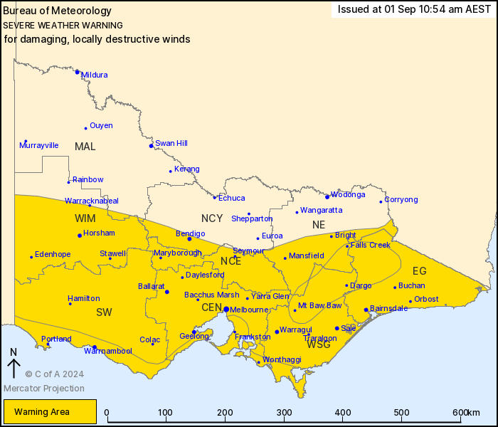
Source: Bureau of Meteorology
For people in Central, East Gippsland, South West, North Central,
West and South Gippsland, Wimmera and parts of Northern Country,
North East and Mallee Forecast Districts.
Issued at 10:54 am Sunday, 1 September 2024.
Damaging winds continuing with DESTRUCTIVE WINDS developing about
coastal and alpine areas late Sunday into early Monday.
Weather Situation: A vigorous west to northwesterly airstream will
continue to bring damaging winds to parts of the state, although
conditions have currently eased somewhat. Winds are expected to
strengthen again Sunday afternoon and evening, ahead of another
strong cold front moving eastwards through the area. Conditions are
expected to finally ease throughout the state during the day on
Monday.
DESTRUCTIVE WEST TO NORTHWESTERLY WINDS with peak gusts of up to
130 km/h are possible from Sunday evening at coastal locations from
the South Australian border to Bellarine Peninsula, southeastern
Melbourne suburbs, and Mornington Peninsula to Wilsons Promontory,
primarily in showers and thunderstorms.
FOR CENTRAL VICTORIA INCLUDING MELBOURNE METROPOLITAN: DAMAGING
WEST TO NORTHWESTERLY WINDS averaging 50 to 65 km/h with peak gusts
of around 100 km/h are possible from late Sunday afternoon.
FOR WESTERN VICTORIA, THE GEELONG AREA, THE MORNINGTON PENINSULA,
GIPPSLAND: DAMAGING WEST TO NORTHWESTERLY WINDS averaging 50 to 65
km/h with peak gusts of around 100 km/h are possible about coastal
areas today, extending throughout western districts on Sunday
afternoon and Gippsland during Sunday evening.
FOR THE NORTHEAST RANGES: DAMAGING WEST TO NORTHWESTERLY WINDS
averaging 60 to 70 km/h with peak gusts to 100 km/h are possible.
DESTRUCTIVE WIND GUSTS up to 130 km/h are possible from Sunday
evening into early Monday.
Broadly, winds will ease throughout the state during Monday.
A Coastal Hazard Warning is also current for the Victorian
coastline. Please refer to
http://www.bom.gov.au/vic/warnings/
Locations which may be affected include Horsham, Warrnambool,
Bendigo, Seymour, Maryborough, Ballarat, Geelong, Melbourne,
Traralgon and Bairnsdale.
Significant wind observations in the past 6 hours to 4:50 AM AEST
Sunday include:
102 km/h wind gust was recorded at Mount William.
98 km/h wind gust was recorded at Mount Hotham Airport.
91 km/h wind gust was recorded at Gelantipy
The State Emergency Service advises that people should:
* If driving conditions are dangerous, safely pull over away from
trees, drains, low-lying areas and floodwater. Avoid travel if
possible.
* Stay safe by avoiding dangerous hazards, such as floodwater,
mud, debris, damaged roads and fallen trees.
* Be aware - heat, fire or recent storms may make trees unstable
and more likely to fall when it's windy or wet.
* Check that loose items, such as outdoor settings, umbrellas and
trampolines are safely secured. Move vehicles under cover or away
from trees.
* Stay indoors and away from windows.
* If outdoors, move to a safe place indoors. Stay away from trees,
drains, gutters, creeks and waterways.
* Stay away from fallen powerlines - always assume they are
live.
* Be aware that in fire affected areas, rainfall run-off into
waterways may contain debris such as ash, soil, trees and rocks.
Heavy rainfall may also increase the potential for landslides and
debris across roads.
* Stay informed: Monitor weather warnings, forecasts and river
levels at the Bureau of Meteorology website, and warnings through
VicEmergency website/app/hotline.
01/Sep/2024 01:13 AM


