
Source: Bureau of Meteorology
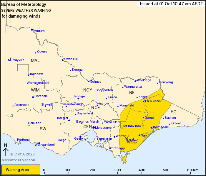
For people in West and South Gippsland and parts of East Gippsland
and North East Forecast Districts.
Issued at 10:47 am Sunday, 1 October 2023.
Damaging winds over elevated terrain and extending to Gippsland on
Sunday.
Weather Situation: A cold front is forecast to sweep across
Victoria during Sunday morning bringing vigorous and gusty winds
ahead of and behind it. Winds are expected to ease during Sunday
evening as a high pressure ridge moves in behind the front.
West to southwesterly strong to DAMAGING WINDS averaging 55 to 65
km/h with peak gusts of around 90 km/h are possible over Gippsland,
the eastern ranges and through the Latrobe Valley during Sunday,
though winds will remain more northwesterly over the eastern
ranges.
DAMAGING WIND GUSTS to around 100 km/h are possible over higher
elevations above 1200 metres.
Damaging winds are expected to ease below warning thresholds by
this evening.
Locations which may be affected include Morwell, Traralgon, Sale,
Moe, Maffra, Bairnsdale, Falls Creek, Mt Buller and Omeo.
Severe weather is no longer occurring in the Central, South West,
North Central and Wimmera districts and the warning for these
districts is CANCELLED.
Significant wind gusts observations to 11:00am Sunday
include:
104km/h at Wilsons Prom at 7:23am
104km/h at Mt Buller at 5:38am
96km/h at Mount William at 4:30am
87km/h at Yarram at 9:38am
87km/h at East Sale Airport at 10:37am
87km/h at Cape Otway at 4:59am
The State Emergency Service advises that people should:
* If driving conditions are dangerous, safely pull over away from
trees, drains, low-lying areas and floodwater. Avoid travel if
possible.
* Stay safe by avoiding dangerous hazards, such as floodwater,
mud, debris, damaged roads and fallen trees.
* Be aware - heat, fire or recent storms may make trees unstable
and more likely to fall when it's windy or wet.
* Check that loose items, such as outdoor settings, umbrellas and
trampolines are safely secured. Move vehicles under cover or away
from trees.
* Stay indoors and away from windows.
* If outdoors, move to a safe place indoors. Stay away from trees,
drains, gutters, creeks and waterways.
* Stay away from fallen powerlines - always assume they are
live.
* Be aware that in fire affected areas, rainfall run-off into
waterways may contain debris such as ash, soil, trees and rocks.
Heavy rainfall may also increase the potential for landslides and
debris across roads.
* Stay informed: Monitor weather warnings, forecasts and river
levels at the Bureau of Meteorology website, and warnings through
VicEmergency website/app/hotline.
01/Oct/2023 12:13 AM

