
Source: Bureau of Meteorology
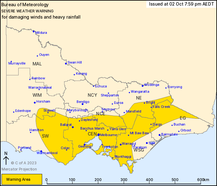
For people in Central, West and South Gippsland and parts of East
Gippsland, South West, North Central, North East and Wimmera
Forecast Districts.
Issued at 7:57 pm Monday, 2 October 2023.
Damaging winds developing through central and eastern Victoria
during Tuesday morning. Heavy rain on the northeastern ranges from
Tuesday afternoon.
Weather Situation: Northwesterly winds will strengthen from early
Tuesday morning ahead of a cold front and associated upper trough.
Heavy rainfall is expected to develop over the ranges in
northeastern Victoria during Tuesday afternoon as the progression
of the front slows.
A low pressure system is forecast to develop over southern New
South Wales during Wednesday. This system is likely to see warnings
continuing across eastern Victoria during Wednesday and into
Thursday.
For CENTRAL VICTORIA, INCLUDING MELBOURNE: Strong winds averaging
50 to 60 km/h with DAMAGING WIND GUSTS of 90 to 100 km/h are
possible from early Tuesday morning. Winds should ease over western
parts of the warning area from around sunrise before easing in
central parts, including Melbourne, by mid to late morning.
For GIPPSLAND AND THE NORTHEAST: DAMAGING WINDS averaging 60 to 70
km/h with peak gusts of 90 to 110 km/h are likely from Tuesday
morning, mainly over elevated areas. Higher terrain above 1200 m
may experience peak gusts of 120 km/h from around sunrise. Winds
are expected to ease during Wednesday night.
HEAVY RAINFALL which may lead to FLASH FLOODING is forecast to
develop over the NORTHEAST RANGES from Tuesday afternoon.
Six-hourly rainfall totals between 50 and 70 mm are possible, with
24-hour totals of 90 to 150 mm. This threat is likely to persist
into Wednesday morning.
Flood watches are current for eastern catchments. Please refer
to
http://www.bom.gov.au/vic/warnings/
Locations which may be affected include Ballarat, Geelong,
Melbourne, Bacchus Marsh, Morwell and Moe.
The State Emergency Service advises that people should:
* If driving conditions are dangerous, safely pull over away from
trees, drains, low-lying areas and floodwater. Avoid travel if
possible.
* Stay safe by avoiding dangerous hazards, such as floodwater,
mud, debris, damaged roads and fallen trees.
* Be aware - heat, fire or recent storms may make trees unstable
and more likely to fall when it's windy or wet.
* Check that loose items, such as outdoor settings, umbrellas and
trampolines are safely secured. Move vehicles under cover or away
from trees.
* Stay indoors and away from windows.
* If outdoors, move to a safe place indoors. Stay away from trees,
drains, gutters, creeks and waterways.
* Stay away from fallen powerlines - always assume they are
live.
* Be aware that in fire affected areas, rainfall run-off into
waterways may contain debris such as ash, soil, trees and rocks.
Heavy rainfall may also increase the potential for landslides and
debris across roads.
* Stay informed: Monitor weather warnings, forecasts and river
levels at the Bureau of Meteorology website, and warnings through
VicEmergency website/app/hotline.
02/Oct/2023 09:12 AM


