
Source: Bureau of Meteorology
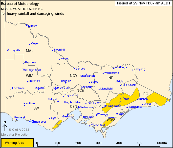
For people in parts of East Gippsland, West and South Gippsland,
Central, South West and North East Forecast Districts.
Issued at 11:07 am Wednesday, 29 November 2023.
Heavy rainfall and possible damaging winds about parts of southern
Victoria.
Weather Situation: A low pressure system over the New South Wales
Riverina will move slowly east to be located off the South Coast of
New South Wales by Thursday. A strong easterly flow south of the
low over southern Victoria drawing in rich moisture from the Tasman
Sea will gradually tend more southeasterly over Gippsland during
Thursday.
HEAVY RAINFALL which may load to FLASH FLOODING is expected to
develop in the warning area today, peaking over the Otway Ranges
this afternoon and over the Gippsland parts of the warning area
overnight and during Thursday. Peak six-hourly totals of 50 to 80
mm are likely with isolated falls up to 100 mm.
24 hourly rainfall totals between 50 to 100m over the Otway Ranges
today with isolated falls to 120mm possible. In the east falls of
80-150mm Thursday and locally up to 200mm over parts of East
Gippsland.
Strong winds from the east to southeast averaging 40 to 60 km/h
with DAMAGING WIND GUSTS of around 90 km/h are possible today,
contracting to East Gippsland only by Thursday.
Conditions should ease during Wednesday evening in the west but
increase overnight and into Thursday in the east, especially East
Gippsland nearer to the low.
Locations which may be affected include Dargo, Mallacoota,
Chandlers Creek, Combienbar, Gelantipy and Mt Baw Baw.
The State Emergency Service advises that people should:
* If driving conditions are dangerous, safely pull over away from
trees, drains, low-lying areas and floodwater. Avoid travel if
possible.
* Stay safe by avoiding dangerous hazards, such as floodwater,
mud, debris, damaged roads and fallen trees.
* Be aware - heat, fire or recent storms may make trees unstable
and more likely to fall when it's windy or wet.
* Check that loose items, such as outdoor settings, umbrellas and
trampolines are safely secured. Move vehicles under cover or away
from trees.
* Stay indoors and away from windows.
* If outdoors, move to a safe place indoors. Stay away from trees,
drains, gutters, creeks and waterways.
* Stay away from fallen powerlines - always assume they are
live.
* Be aware that in fire affected areas, rainfall run-off into
waterways may contain debris such as ash, soil, trees and rocks.
Heavy rainfall may also increase the potential for landslides and
debris across roads.
* Stay informed: Monitor weather warnings, forecasts and river
levels at the Bureau of Meteorology website, and warnings through
VicEmergency website/app/hotline.
29/Nov/2023 12:21 AM

