
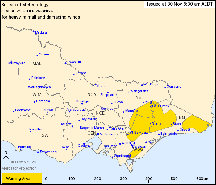
Source: Bureau of Meteorology
For people in parts of East Gippsland, North East and West and
South Gippsland Forecast Districts.
Issued at 8:30 am Thursday, 30 November 2023.
Heavy rainfall and damaging winds continue about parts of eastern
Victoria
A broad low pressure system near the southeast coast of New South
Wales is directing a vigorous southeasterly flow with rich moisture
over eastern Victoria. The low will move slowly towards the east,
moderating conditions by late Thursday.
HEAVY RAINFALL which may lead to FLASH FLOODING is expected to
continue over parts of eastern Victoria, primarily about the
windward slopes and peaks of the ranges. Peak six-hourly totals of
40 to 80 mm are likely with isolated falls up to 100 mm.
DAMAGING WINDS from the southeast averaging 60 to 70 km/h with
peak gusts of 90 to 100 km/h are likely across the higher
topography and immediate lee slopes of the Alpine areas, and are
possible though slightly weaker elsewhere in the warning
area.
Conditions should generally ease by late Thursday evening,
although heavy rain may persist into early Friday morning for far
eastern Gippsland.
Several flood watches and warnings are also current for these
areas. Please refer to http://www.bom.gov.au/vic/warnings/
Locations which may be affected include Buchan, Mallacoota, Mt Baw
Baw, Falls Creek, Mt Hotham and Omeo.
Significant rainfall in the 6 hours to 8:00am:
70.0 mm at Chandlers Creek
69 mm at Mount Waldron
Mount Hotham reported sustained gale force winds with gusts to 93
km/h at around 8:00am
Mount buller reported sustained gale force winds at around
8:00am.
The State Emergency Service advises that people should:
* If driving conditions are dangerous, safely pull over away from
trees, drains, low-lying areas and floodwater. Avoid travel if
possible.
* Stay safe by avoiding dangerous hazards, such as floodwater,
mud, debris, damaged roads and fallen trees.
* Be aware - heat, fire or recent storms may make trees unstable
and more likely to fall when it's windy or wet.
* Check that loose items, such as outdoor settings, umbrellas and
trampolines are safely secured. Move vehicles under cover or away
from trees.
* Stay indoors and away from windows.
* If outdoors, move to a safe place indoors. Stay away from trees,
drains, gutters, creeks and waterways.
* Stay away from fallen powerlines - always assume they are
live.
* Be aware that in fire affected areas, rainfall run-off into
waterways may contain debris such as ash, soil, trees and rocks.
Heavy rainfall may also increase the potential for landslides and
debris across roads.
* Stay informed: Monitor weather warnings, forecasts and river
levels at the Bureau of Meteorology website, and warnings through
VicEmergency website/app/hotline.
29/Nov/2023 09:46 PM


