
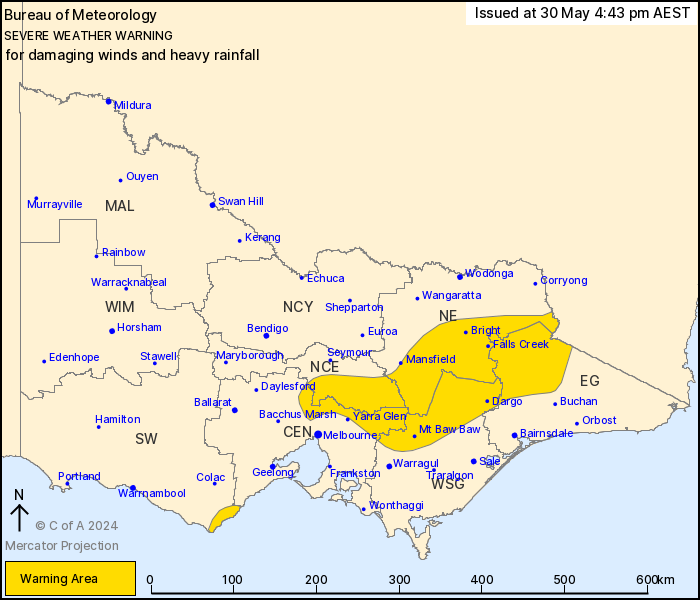
Source: Bureau of Meteorology
For people in parts of Central, East Gippsland, North Central,
North East, West and South Gippsland and South West Forecast
Districts.
Issued at 4:43 pm Thursday, 30 May 2024.
Damaging wind gusts and heavy rainfall expected across elevated
parts of the state today and Friday.
Weather Situation: A vigorous cold front continues to progress
eastwards through the state, clearing from the west today and
exiting the state on Friday morning. Northwesterly winds will
strengthen across elevated areas and their immediate lee slopes
during this evening and on Friday morning. Heavy rainfall is
expected to develop over the ranges in northeastern Victoria from
late this evening into early Friday morning.
For the OTWAY RANGES: Strong winds averaging 50 to 60 km/h with
DAMAGING WIND GUSTS of around 90 km/h are expected over the Otway
Ranges this evening and tonight, easing Friday morning.
For the CENTRAL AND NORTHEAST RANGES: DAMAGING WINDS averaging 60
to 70 km/h with peak gusts of around 90 km/h are occurring this
afternoon. Winds will ease this evening over the Central Ranges
before and will contract to the Northeast Ranges early in the
evening.
DAMAGING WINDS averaging 60 to 70 km/h with peak gusts of around
110km/h are possible for elevated peaks over 1200 m
overnight.
For NORTHEAST RANGES: HEAVY RAINFALL which may lead to FLASH
FLOODING is forecast to develop during late this evening into early
Friday morning. Six-hourly rainfall totals between 40 and 60 mm are
likely, with localised falls up to 80 mm.
Heavy rainfall is expected to ease by late Friday morning, and the
damaging winds by Friday afternoon.
Locations which may be affected include Bright, Mt Baw Baw, Falls
Creek, Mt Hotham, Mt Buller and Omeo.
Severe weather is no longer occurring in the Wimmera district and
the warning for this district is CANCELLED.
122 km/h wind gust was recorded at Mount William at 7:41am.
104 km/h wind gust was recorded at Mount Hotham at 3:51 pm.
102 km/h wind gust was recorded at Mount Buller Airport at 3:13
pm.
63 km/h 10-minute mean winds were recorded at Kilmore gap at
7:20am.
The State Emergency Service advises that people should:
* If driving conditions are dangerous, safely pull over away from
trees, drains, low-lying areas and floodwater. Avoid travel if
possible.
* Stay safe by avoiding dangerous hazards, such as floodwater,
mud, debris, damaged roads and fallen trees.
* Be aware - heat, fire or recent storms may make trees unstable
and more likely to fall when it's windy or wet.
* Check that loose items, such as outdoor settings, umbrellas and
trampolines are safely secured. Move vehicles under cover or away
from trees.
* Stay indoors and away from windows.
* If outdoors, move to a safe place indoors. Stay away from trees,
drains, gutters, creeks and waterways.
* Stay away from fallen powerlines - always assume they are
live.
* Be aware that in fire affected areas, rainfall run-off into
waterways may contain debris such as ash, soil, trees and rocks.
Heavy rainfall may also increase the potential for landslides and
debris across roads.
* Stay informed: Monitor weather warnings, forecasts and river
levels at the Bureau of Meteorology website, and warnings through
VicEmergency website/app/hotline.
30/May/2024 06:48 AM

