
Source: Bureau of Meteorology
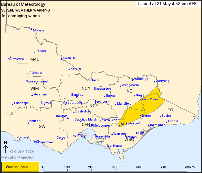
For people in parts of East Gippsland, North East and West and
South Gippsland Forecast Districts.
Issued at 4:53 am Friday, 31 May 2024.
Damaging wind gusts expected to persist over the eastern ranges
today.
Weather Situation: A vigorous cold front is located over far
eastern Victoria and is currently clearing to the east.
West-northwesterly winds will likely restrengthen a little across
elevated areas today as the post-frontal air stream
strengthens.
For the NORTHEAST RANGES: DAMAGING WINDS have temporarily eased
over much of the area, but stronger winds averaging 60 to 70 km/h
with peak gusts of around 100 km/h are expected to redevelop over
the highest terrain during this morning and persist into the
afternoon.
DESTRUCTIVE WIND GUSTS exceeding 125 km/h are no longer
expected.
For the OTWAY RANGES: Damaging wind gusts are no longer
expected.
Rainfall rates have eased in the past few hours, and no further
heavy rainfall heavy enough to produce flash flooding is expected
over the area. Damaging winds are expected to ease throughout by
late this afternoon.
Locations which may be affected include Dargo, Mt Baw Baw, Falls
Creek, Mt Hotham and Omeo.
Severe weather is no longer occurring in the Central, South West,
Northern Country and North Central districts and the warning for
these districts is CANCELLED.
124 km/h wind gust was recorded at Falls Creek at 2 am.
79 mm was recorded in the 6 hours to 4 am at Mount Hotham
The State Emergency Service advises that people should:
* If driving conditions are dangerous, safely pull over away from
trees, drains, low-lying areas and floodwater. Avoid travel if
possible.
* Stay safe by avoiding dangerous hazards, such as floodwater,
mud, debris, damaged roads and fallen trees.
* Be aware - heat, fire or recent storms may make trees unstable
and more likely to fall when it's windy or wet.
* Check that loose items, such as outdoor settings, umbrellas and
trampolines are safely secured. Move vehicles under cover or away
from trees.
* Stay indoors and away from windows.
* If outdoors, move to a safe place indoors. Stay away from trees,
drains, gutters, creeks and waterways.
* Stay away from fallen powerlines - always assume they are
live.
* Be aware that in fire affected areas, rainfall run-off into
waterways may contain debris such as ash, soil, trees and rocks.
Heavy rainfall may also increase the potential for landslides and
debris across roads.
* Stay informed: Monitor weather warnings, forecasts and river
levels at the Bureau of Meteorology website, and warnings through
VicEmergency website/app/hotline.
30/May/2024 09:24 PM

