
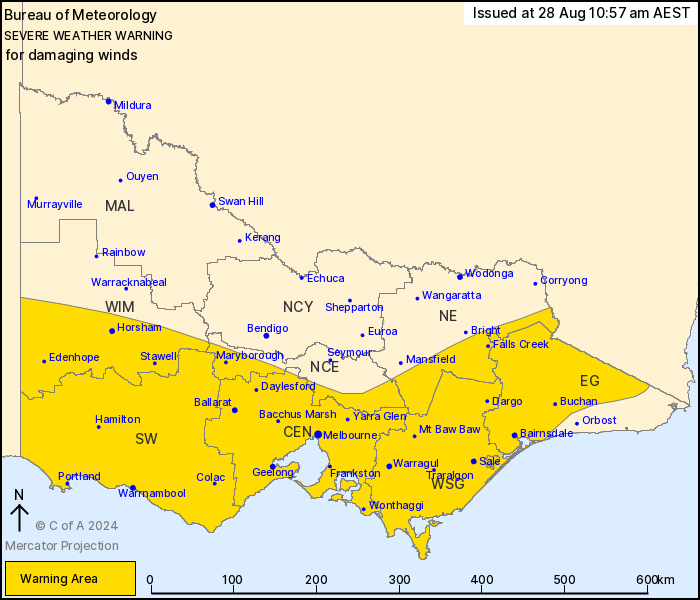
Source: Bureau of Meteorology
For people in Central, East Gippsland, South West, West and South
Gippsland and parts of North Central, North East and Wimmera
Forecast Districts.
Issued at 10:57 am Wednesday, 28 August 2024.
Damaging winds to continue over parts of Victoria today.
Weather Situation: A vigorous westerly airstream with an embedded
front will continue to affect Victoria today, easing tonight as the
cold front moves off the coast and over the Tasman Sea.
DAMAGING WINDS averaging 60 to 70 km/h with peak gusts around 110
km/h are possible across the warning area. The highest risk period
is during the afternoon or with approaching showers. Coastal
locations are at higher risk, especially the most southern coasts
where thunderstorms are possible.
Winds are expected to rapidly ease inland in the evening then
contract to the Gippsland coast by tonight before easing below
warning threshold early Thursday.
Locations which may be affected include Horsham, Warrnambool,
Maryborough, Ballarat, Geelong, Melbourne, Traralgon and
Bairnsdale.
Severe weather is no longer occurring in the Northern Country
district and the warning for this district is CANCELLED.
Significant wind observations to 10:50am AEST Wednesday
include:
Sustained 96 km/h winds with a 128 km/h wind gust were recorded at
Mount Buller at 2:48 am
124 km/h wind gust was recorded at Cape Otway at 4:24 am
119 km/h wind gust was recorded at Wilsons Promontory at 8:08
am
106 km/h wind gust was recorded at Portland at 3:16 am
104 km/h wind gust was recorded at Falls Creek at 4:48 am
96 km/h wind gust was recorded at Avalon Airport at 1:37 am
Sustained 70km/h winds with a 96 km/h wind gust were recorded at
Mount Gellibrand at 10:47 am
The State Emergency Service advises that people should:
* If driving conditions are dangerous, safely pull over away from
trees, drains, low-lying areas and floodwater. Avoid travel if
possible.
* Stay safe by avoiding dangerous hazards, such as floodwater,
mud, debris, damaged roads and fallen trees.
* Be aware - heat, fire or recent storms may make trees unstable
and more likely to fall when it's windy or wet.
* Check that loose items, such as outdoor settings, umbrellas and
trampolines are safely secured. Move vehicles under cover or away
from trees.
* Stay indoors and away from windows.
* If outdoors, move to a safe place indoors. Stay away from trees,
drains, gutters, creeks and waterways.
* Stay away from fallen powerlines - always assume they are
live.
* Be aware that in fire affected areas, rainfall run-off into
waterways may contain debris such as ash, soil, trees and rocks.
Heavy rainfall may also increase the potential for landslides and
debris across roads.
* Stay informed: Monitor weather warnings, forecasts and river
levels at the Bureau of Meteorology website, and warnings through
VicEmergency website/app/hotline.
28/Aug/2024 01:02 AM

