
Source: Bureau of Meteorology
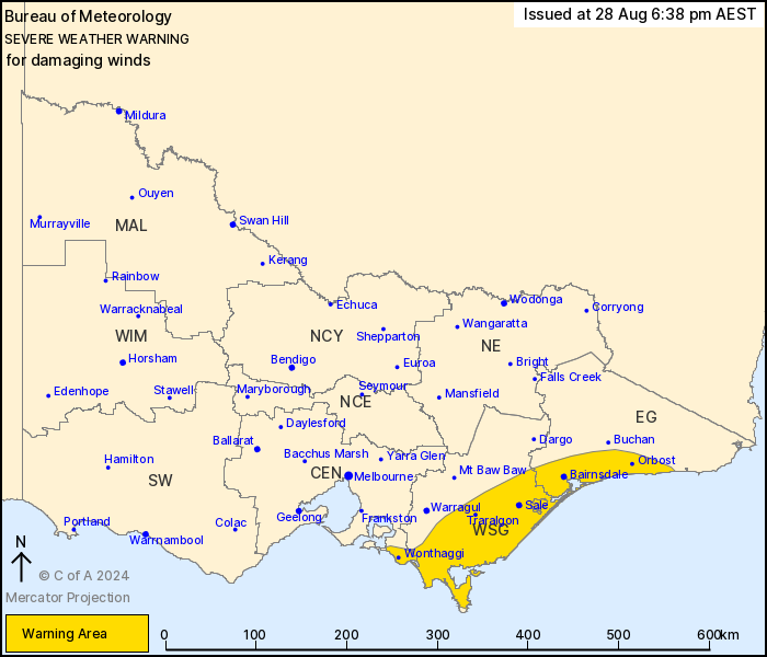
For people in parts of East Gippsland, West and South Gippsland
and Central Forecast Districts.
Issued at 6:38 pm Wednesday, 28 August 2024.
Damaging winds easing this evening.
Weather Situation: A vigorous westerly airstream with an embedded
front will continue easing from the west tonight as the cold front
moves off the coast and over the Tasman Sea.
DAMAGING WINDS averaging 60 to 70 km/h with peak gusts around 100
km/h are possible across the warning area. Gusts to 110km/h remain
possible over coastal locations for the next hour.
Winds are expected to contract to the Gippsland coast over the
next few hours and ease below warning threshold overnight.
Locations which may be affected include Morwell, Traralgon, Sale,
Moe, Bairnsdale and Orbost.
Severe weather is no longer occurring in the South West, North
Central and North East districts and the warning for these
districts is CANCELLED.
Significant wind observations to 4:50pm AEST Wednesday
include:
Sustained 106 km/h winds with a 154 km/h wind gust were recorded
at Wilsons Promontory at 4:06 pm
Sustained 106 km/h winds with a 131 km/h wind gust were recorded
at Mount Gellibrand at 2:32 pm
Sustained 80 km/h winds with a 113 km/h wind gust were recorded at
Cape Otway at 2:32 pm
Sustained 78 km/h winds with a 104 km/h wind gust were recorded at
Yanakie at 3:07 pm
Sustained 76 km/h winds with a 102 km/h wind gust were recorded at
Avalon at 3:56 pm
100 km/h wind gust was recorded at Melbourne Airport at 4:34
pm.
98 km/h wind gust was recorded at Pound Creek at 3:21 pm and at
Yarram at 4:01pm
94 km/h wind gust was recorded at Essendon at 4:33 pm and at
Portland at 1:17pm
93 km/h wind gust was recorded at at Point Cook at 3:26 pm and at
Warrnambool at 2:01 pm
The State Emergency Service advises that people should:
* If driving conditions are dangerous, safely pull over away from
trees, drains, low-lying areas and floodwater. Avoid travel if
possible.
* Stay safe by avoiding dangerous hazards, such as floodwater,
mud, debris, damaged roads and fallen trees.
* Be aware - heat, fire or recent storms may make trees unstable
and more likely to fall when it's windy or wet.
* Check that loose items, such as outdoor settings, umbrellas and
trampolines are safely secured. Move vehicles under cover or away
from trees.
* Stay indoors and away from windows.
* If outdoors, move to a safe place indoors. Stay away from trees,
drains, gutters, creeks and waterways.
* Stay away from fallen powerlines - always assume they are
live.
* Be aware that in fire affected areas, rainfall run-off into
waterways may contain debris such as ash, soil, trees and rocks.
Heavy rainfall may also increase the potential for landslides and
debris across roads.
* Stay informed: Monitor weather warnings, forecasts and river
levels at the Bureau of Meteorology website, and warnings through
VicEmergency website/app/hotline.
28/Aug/2024 08:50 AM

