
Source: Bureau of Meteorology
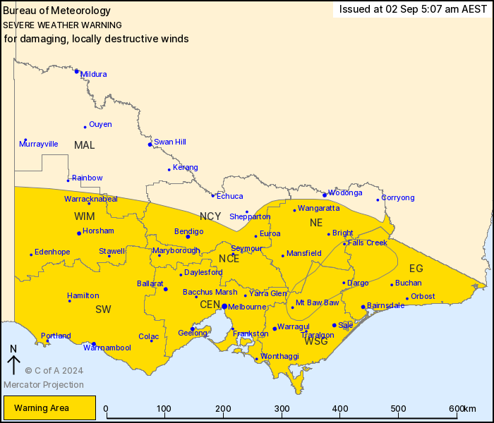
For people in Central, East Gippsland, South West, North Central,
North East, West and South Gippsland, Wimmera and parts of Northern
Country and Mallee Forecast Districts.
Issued at 5:07 am Monday, 2 September 2024.
Risk of damaging winds continuing into this afternoon. DESTRUCTIVE
WINDS possible over the eastern ranges for another hour or
two.
Weather Situation: A strong cold front over central Victoria to
the east of Melbourne will continue to move rapidly eastwards
today. A vigorous west to northwesterly airstream is in place ahead
of the front, shifting west to southwesterly following its passage.
The strength of these winds aloft, combined with scattered lines of
showers and a few thunderstorms will continue to bring damaging
winds to parts of the state today. Conditions are expected to
gradually ease throughout the state during late afternoon and
evening today.
FOR THE NORTHEAST RANGES: DAMAGING WEST TO NORTHWESTERLY WINDS
averaging 60 to 70 km/h with peak gusts to 110 km/h, easing in the
afternoon. DESTRUCTIVE WIND GUSTS up to 130 km/h for another hour
or two, before easing later this morning.
REMAINING WARNING AREA EAST OF MELBOURNE: DAMAGING WEST TO
NORTHWESTERLY WINDS averaging 50 to 65 km/h with peak gusts of
around 110 km/h early this morning. Winds shifting west to
southwesterly during the day and easing a little, although gusts to
90 km/h will remain possible into the afternoon. Damaging winds
gusts will be most likely associated with scattered shower and
thunderstorm activity.
REMAINING WARNING AREA WEST OF MELBOURNE: DAMAGING WEST TO
SOUTHWESTERLY WINDS averaging 50 to 65 km/h with peak gusts of
around 110 km/h around exposed coastal parts. Further inland,
strong southwesterly winds with damaging gusts to 90 km/h are
possible through the day to late afternoon. Damaging winds gusts
will be most likely associated with scattered shower and
thunderstorm activity.
Winds are expected to ease through most of the Victoria Monday
evening.
A Coastal Hazard Warning is also current for the Victorian
coastline. Please refer to
http://www.bom.gov.au/vic/warnings/
Locations which may be affected include Horsham, Warrnambool,
Bendigo, Seymour, Maryborough, Ballarat, Geelong, Melbourne,
Wangaratta, Traralgon and Bairnsdale.
Significant wind observations in the past 6 hours to 4:50 AM AEST
Monday include:
133 km/h wind gust was recorded at Mount Gellibrand
131 km/h wind gust was recorded at Falls Creek km/h wind gust was
recorded at Cape otway
113 km/h wind gust was recorded at St Kilda Harbour
109 km/h wind gust was recorded at Casterton
98 km/h wind gust was recorded at Wangaratta
113 km/h wind gust was recorded at Aireys Inlet
93 km/h wind gust was recorded at Warracknabeal
The State Emergency Service advises that people should:
* If driving conditions are dangerous, safely pull over away from
trees, drains, low-lying areas and floodwater. Avoid travel if
possible.
* Stay safe by avoiding dangerous hazards, such as floodwater,
mud, debris, damaged roads and fallen trees.
* Be aware - heat, fire or recent storms may make trees unstable
and more likely to fall when it's windy or wet.
* Check that loose items, such as outdoor settings, umbrellas and
trampolines are safely secured. Move vehicles under cover or away
from trees.
* Stay indoors and away from windows.
* If outdoors, move to a safe place indoors. Stay away from trees,
drains, gutters, creeks and waterways.
* Stay away from fallen powerlines - always assume they are
live.
* Be aware that in fire affected areas, rainfall run-off into
waterways may contain debris such as ash, soil, trees and rocks.
Heavy rainfall may also increase the potential for landslides and
debris across roads.
* Stay informed: Monitor weather warnings, forecasts and river
levels at the Bureau of Meteorology website, and warnings through
VicEmergency website/app/hotline.
01/Sep/2024 08:20 PM


