
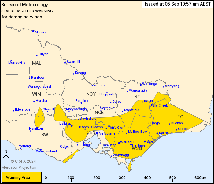
Source: Bureau of Meteorology
For people in East Gippsland, West and South Gippsland and parts
of Central, South West, North Central, North East and Wimmera
Forecast Districts.
Issued at 10:57 am Thursday, 5 September 2024.
Damaging winds over elevated areas today, expanding and increasing
Friday.
Weather Situation: Strong north to northwesterly winds across
Victoria will increase further ahead of a cold front which is
expected to cross the State from the west during Friday.
For the CENTRAL AND EASTERN RANGES: DAMAGING WINDS averaging 50 to
60 km/h with peak gusts around 90 km/h remain possible today and
become more likely overnight and Friday with winds strengthening to
average 60 to 70 km/h and peak gusts to 110km/h. Over ALPINE AREAS
above 1400m gusts to 100km/h are possible today and to 120km/h
overnight and Friday morning.
For the GRAMPIANS and PYRENEES: DAMAGING WINDS averaging 55 to 65
km/h with peak gusts of 90 to 100 km/h are expected to develop late
on Thursday night and early Friday morning.
For the OTWAY RANGES AND SURF COAST: DAMAGING WIND GUSTS with peak
gusts of around 90 km/h are possible again during Friday
morning.
For remaining areas of the CENTRAL AND GIPPSLAND DISTRICTS
including outer suburbs of MELBOURNE and GEELONG: Winds
strengthening to average 50 to 60km/h with DAMAGING WIND GUSTS
around 90 to 100km/h possible from early Friday morning, extending
to parts of the Gippsland coast after dawn.
High based shower or thunderstorm activity may produce sudden
damaging wind gusts at any time.
Winds should ease from the west during Friday with the passage of
the front.
Locations which may be affected include Ballarat, Bacchus Marsh,
Morwell, Traralgon, Sale, Moe, Bairnsdale, Orbost and Falls
Creek.
Significant observations in the 6 hours to 10:45am include:
Sustained 65 km/h winds and 91 km/h wind gust were recorded at
Mount Buller at 8:45am
Sustained 63 km/h winds were recorded at Kilmore Gap at 9:38 am
and at Mount Hotham at 7:30 am
The State Emergency Service advises that people should:
* If driving conditions are dangerous, safely pull over away from
trees, drains, low-lying areas and floodwater. Avoid travel if
possible.
* Stay safe by avoiding dangerous hazards, such as floodwater,
mud, debris, damaged roads and fallen trees.
* Be aware - heat, fire or recent storms may make trees unstable
and more likely to fall when it's windy or wet.
* Check that loose items, such as outdoor settings, umbrellas and
trampolines are safely secured. Move vehicles under cover or away
from trees.
* Stay indoors and away from windows.
* If outdoors, move to a safe place indoors. Stay away from trees,
drains, gutters, creeks and waterways.
* Stay away from fallen powerlines - always assume they are
live.
* Be aware that in fire affected areas, rainfall run-off into
waterways may contain debris such as ash, soil, trees and rocks.
Heavy rainfall may also increase the potential for landslides and
debris across roads.
* Stay informed: Monitor weather warnings, forecasts and river
levels at the Bureau of Meteorology website, and warnings through
VicEmergency website/app/hotline.
05/Sep/2024 01:16 AM


