
Source: Bureau of Meteorology
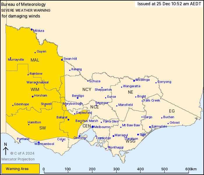
For people in Mallee, South West, Wimmera and parts of Central,
Northern Country and North Central Forecast Districts.
Issued at 10:52 am Wednesday, 25 December 2024.
Damaging wind gusts to develop over western and central Victoria
from Thursday morning.
Weather Situation: North to northwesterly winds will strengthen
over western Victoria ahead of a cold front which reaches the state
border in the early afternoon Thursday before crossing the western
districts through the afternoon and reaching central districts
around sunset. Winds will shift to the west to southwest on and
immediately behind the front before weakening by late Thursday
evening.
North to northwesterly winds with DAMAGING WIND GUSTS with peak
gusts of around 90 km/h are likely over the Grampians and Central
ranges northwest of Melbourne from around sunrise on Thursday
morning, before easing by the early afternoon.
Isolated DAMAGING WIND GUSTS with peak gusts of around 100 km/h
are possible again from the early afternoon over broader parts of
the Mallee, Wimmera, and South West districts as winds shift to the
west to southwest along and immediately behind the cold front
progressing through the state.
Winds are expected to ease below warning thresholds over the
remaining warning area by late Thursday evening once the cold front
reaches the central districts.
Locations which may be affected include Mildura, Swan Hill,
Horsham, Stawell, Warracknabeal, Hamilton, Ararat, Ballarat and
Bacchus Marsh.
The State Emergency Service advises that people should:
* If driving conditions are dangerous, safely pull over away from
trees, drains, low-lying areas and floodwater. Avoid travel if
possible.
* Stay safe by avoiding dangerous hazards, such as floodwater,
mud, debris, damaged roads and fallen trees.
* Be aware - heat, fire or recent storms may make trees unstable
and more likely to fall when it's windy or wet.
* Check that loose items, such as outdoor settings, umbrellas and
trampolines are safely secured. Move vehicles under cover or away
from trees.
* Stay indoors and away from windows.
* If outdoors, move to a safe place indoors. Stay away from trees,
drains, gutters, creeks and waterways.
* Stay away from fallen powerlines - always assume they are
live.
* Be aware that in fire affected areas, rainfall run-off into
waterways may contain debris such as ash, soil, trees and rocks.
Heavy rainfall may also increase the potential for landslides and
debris across roads.
* Stay informed: Monitor weather warnings, forecasts and river
levels at the Bureau of Meteorology website, and warnings through
VicEmergency website/app/hotline.
25/Dec/2024 12:01 AM

