
Source: Bureau of Meteorology
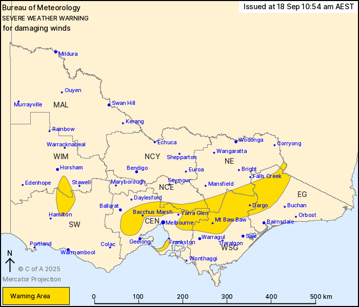
For people in parts of Central, East Gippsland, South West, North
Central, North East, West and South Gippsland and Wimmera Forecast
Districts.
Issued at 10:54 am Thursday, 18 September 2025.
Damaging winds developing over parts of the state during
Friday.
Weather Situation: Northwesterly winds strengthen on Friday ahead
of an approaching cold front. The cold front will cross Victoria
during Friday evening and move into the Tasman Sea during Saturday
morning, with winds shifting westerly and easing in its wake.
Northwesterly DAMAGING WINDS averaging 55 to 65 km/h with peak
gusts of around 90 km/h are possible from mid Friday morning,
including northern parts of Melbourne and the Mornington Peninsula.
DAMAGING WINDS becoming likely from late Friday morning, with peak
gusts of around 100 km/h for areas above 1200 metres.
Winds are expected to temporarily ease during Friday afternoon,
before increasing again and shifting westerly as the front moves
through central Victoria in the evening. Winds will gradually ease
from the west behind the front, easing throughout the state by
early Saturday morning.
Locations which may be affected include Bacchus Marsh, Dargo, Mt
Baw Baw, Rosebud, Omeo, and parts of the Melbourne Metropolitan
Area.
The State Emergency Service advises that people should:
* If driving conditions are dangerous, safely pull over away from
trees, drains, low-lying areas and floodwater. Avoid travel if
possible.
* Stay safe by avoiding dangerous hazards, such as floodwater,
mud, debris, damaged roads and fallen trees.
* Be aware - heat, fire or recent storms may make trees unstable
and more likely to fall when it's windy or wet.
* Check that loose items, such as outdoor settings, umbrellas and
trampolines are safely secured. Move vehicles under cover or away
from trees.
* Stay indoors and away from windows.
* If outdoors, move to a safe place indoors. Stay away from trees,
drains, gutters, creeks and waterways.
* Stay away from fallen powerlines - always assume they are
live.
* Be aware that in fire affected areas, rainfall run-off into
waterways may contain debris such as ash, soil, trees and rocks.
Heavy rainfall may also increase the potential for landslides and
debris across roads.
* Stay informed: Monitor weather warnings, forecasts and river
levels at the Bureau of Meteorology website, and warnings through
VicEmergency website/app/hotline.
18/Sep/2025 01:06 AM


