
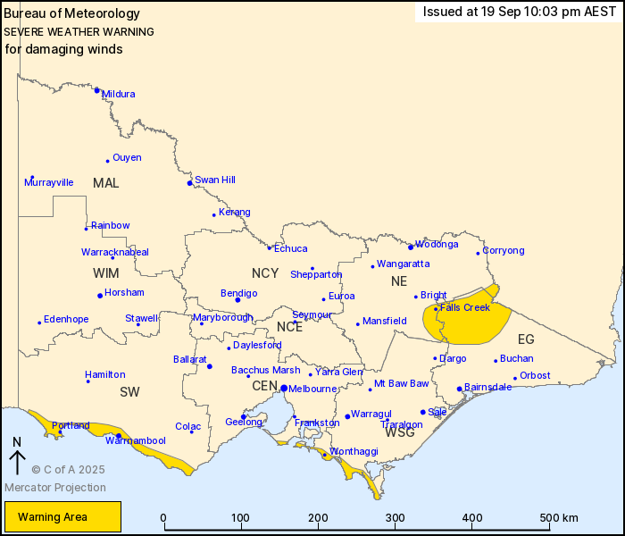
Source: Bureau of Meteorology
For people in parts of East Gippsland, South West, Central, North
East and West and South Gippsland Forecast Districts.
Issued at 10:03 pm Friday, 19 September 2025.
Damaging winds continue in the far northeast and along the exposed
south coast into early Saturday morning
Weather Situation: A cold front is moving through central parts of
the state, reaching eastern districts this evening and will move
into the Tasman Sea during early Saturday morning. Strong and gusty
winds persist about southern coastal areas in the wake of the
front.
For parts of the EASTERN RANGES: DAMAGING NORTHWESTERLY WINDS
averaging 55 to 65 km/h with peak gusts of around 100 km/h are
likely during the late evening, before easing early Saturday
morning.
For exposed parts of the SOUTHWEST COAST and BASS COAST: West to
southwesterly winds averaging 50 to 60 km/h with DAMAGING WIND
GUSTS of around 90 km/h are possible. Conditions will ease along
the southwest coast during early Saturday morning and along the
Bass Coast near sunrise.
Locations which may be affected include Warrnambool, Portland,
Wonthaggi, Falls Creek, Mt Hotham, Omeo and Tidal River.
Severe weather is no longer occurring in the Wimmera district and
the warning for this district is CANCELLED.
91 km/h wind gust was recorded at Mount Hotham at 9:08 pm.
98 km/h wind gust was recorded at Mount Buller Airport at 7:59
pm.
98 km/h wind gust was recorded at Mount Gellibrand at 7:11
pm.
91 km/h wind gust was recorded at Cape Otway Lighthouse at 6:30
pm.
The State Emergency Service advises that people should:
* If driving conditions are dangerous, safely pull over away from
trees, drains, low-lying areas and floodwater. Avoid travel if
possible.
* Stay safe by avoiding dangerous hazards, such as floodwater,
mud, debris, damaged roads and fallen trees.
* Be aware - heat, fire or recent storms may make trees unstable
and more likely to fall when it's windy or wet.
* Check that loose items, such as outdoor settings, umbrellas and
trampolines are safely secured. Move vehicles under cover or away
from trees.
* Stay indoors and away from windows.
* If outdoors, move to a safe place indoors. Stay away from trees,
drains, gutters, creeks and waterways.
* Stay away from fallen powerlines - always assume they are
live.
* Be aware that in fire affected areas, rainfall run-off into
waterways may contain debris such as ash, soil, trees and rocks.
Heavy rainfall may also increase the potential for landslides and
debris across roads.
* Stay informed: Monitor weather warnings, forecasts and river
levels at the Bureau of Meteorology website, and warnings through
VicEmergency website/app/hotline.
19/Sep/2025 12:12 PM


