
Source: Bureau of Meteorology
Issued at 11:52 am AWST on Thursday 19 February 2026 Flood Watch
Number: 4
FURTHER HEAVY RAIN AND LOCALISED FLOODING POSSIBLE IN PARTS OF THE
FLOOD WATCH AREA OVER COMING DAYS
A tropical low is centred over southwest Kimberley, most likely
remaining over land and moving west to the Pilbara coast later in
the week.
Since Sunday 15th February, up to 300 mm of rain has been recorded
at Broome and surrounding areas near the Roebuck plains.
Although rain has since eased, very localised areas of heavier
rainfall are possible from thunderstorms or convective bands as
they form around the low.
This may impact the Flood Watch area in the coming days.
Catchments in the Flood Watch area are wet due to recent rainfall,
with elevated river levels and flood impacts occurring in some
catchments.
Forecast rainfall in the affected catchments is expected to result
in further river rises, areas of flooding and adversely impact road
conditions. Some roads may become impassable and communities linked
by roads may become isolated.
The situation will be monitored closely and Flood Warnings will be
issued as required.
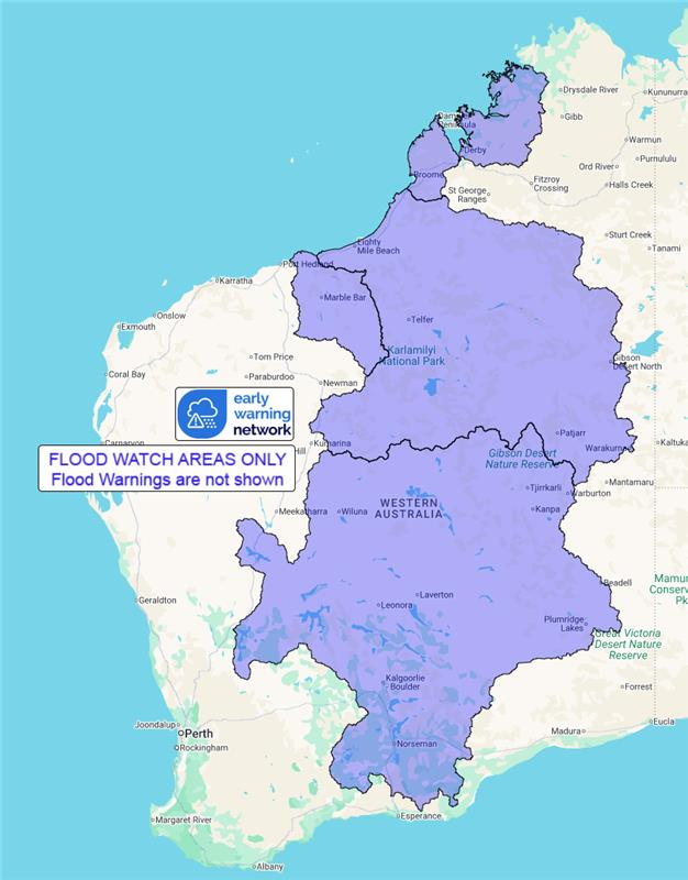
Catchments likely to be affected include:
De Grey River
West Kimberley Rivers
Salt Lakes District Rivers
Sandy Desert
A minor flood warning is current for the Fitzroy River
catchment.
For the latest flood and weather warnings see
www.bom.gov.au/weather-and-climate/warnings-and-alerts
For the latest rainfall and river level information see
www.bom.gov.au/australia/flood
Safety Advice:
* Don't drive, walk, swim or play in floodwater because it is
dangerous.
* Stay away from flooded drains, rivers, streams and
waterways.
* Obey road closure signs. Plan ahead so you don't drive on
flooded roads.
* Check the ABC and local media for updates. The situation can
change quickly, so stay informed.
* For local emergency management warnings and advice visit
www.emergency.wa.gov.au/.
Rainfall and River
Conditions Map
19/Feb/2026 04:17 AM

