
Source: Bureau of Meteorology
Flood Watch Number: 2
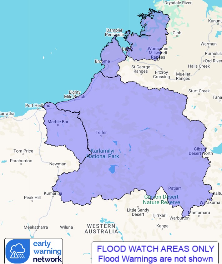
FLOODING POSSIBLE FOR THE WEST KIMBERLEY COASTAL RIVERS FROM
SUNDAY AND FOR THE DE GREY RIVER AND PARTS OF SANDY DESERT FROM
TUESDAY
A tropical low is forming near the north Kimberley coast. The low
is forecast to move southwest off the Kimberley coast and develop,
potentially reaching cyclone intensity on Monday. The system is
then forecast to move further to the southwest towards the Pilbara
coast during Tuesday.
A Tropical Cyclone Advice is current for Western Australia.
Catchments across the Flood Watch area, particularly towards the
coast, have become wet with recent rainfall.
Locally heavy falls are possible near the Kimberley coast between
Cockatoo Island and Broome from Sunday, potentially becoming more
widespread on Monday. Widespread daily rainfall totals of 30-60 mm
are forecast around the Kimberley coast for Sunday and Monday, with
isolated higher totals in excess of 100 mm possible. Higher daily
totals are possible during the week depending on the development
and track of the low.
Further rainfall is forecast in the north and west Kimberley and
possibly in the east Pilbara on Tuesday and Wednesday, with
moderate to heavy falls possible.
Forecast rainfall in the flood watch area is expected to result in
river rises, areas of flooding and may adversely affect road
conditions. Roads may become impassable and some communities may
become isolated. Significant disruption of transportation network
and extensive road closures are possible.
Catchments likely to be affected include:
West Kimberley Rivers
De Grey River
Sandy Desert
This flood watch is available by dialling 1300 659 213. For more
information on the Flood Watch Service visit
http://www.bom.gov.au/water/floods/floodWarningServices.shtml
Flood Safety Advice:
DFES advises people and communities to be aware that flooding is
possible and be prepared to relocate equipment and livestock. Watch
water levels. Travellers need to be aware that road conditions may
be adversely affected and travel plans may need to be reconsidered.
Do not drive into water of unknown depth and velocity.
Community information is available from DFES at
www.emergency.wa.gov.au/
Current river levels are available from Department of Water and
Environmental Regulation at
www.water.wa.gov.au/maps-and-data/monitoring/river-level-monitoring
Rainfall and River
Conditions Map
09/Feb/2025 06:27 AM

