Source: Bureau of Meteorology
Refer to EmergencyWA for AWS alerts
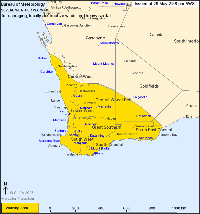
For people in Central West, Lower West, South West, South Coastal,
South East Coastal, Great Southern, Central Wheat Belt and parts of
Goldfields, Gascoyne and Eucla districts.
Issued at 2:58 pm Friday, 29 May 2026.
DAMAGING TO LOCALLY DESTRUCTIVE WINDS TO AFFECT THE SOUTH WEST
LAND DIVISION FROM SATURDAY EVENING.
Weather Situation: A strong cold front will sweep over western
districts overnight on Saturday, bringing damaging to locally
destructive wind gusts and periods of heavy rainfall. The front
will first affect the Central West during Saturday evening, before
extending southwards to parts of the Lower West and South West,
including Perth, before sunrise early on Sunday morning. During
Sunday, a deepening low pressure system approaches the southwest
and will bring another burst of damaging to locally destructive
winds to western and southern parts of the South West Land
Division. By Monday the low pressure system is expected to move to
the east and the risk of damaging winds extends to inland
parts.
DAMAGING TO LOCALLY DESTRUCTIVE WIND GUSTS in excess of 125 km/h
are possible in showers and thunderstorms around the front moving
over the Central West during late Saturday evening and the Lower
West and South West, including Perth, before sunrise on Sunday
morning.
Isolated DAMAGING WIND GUSTS to 90 km/h are possible in showers
and thunderstorms over western parts of the South West Land
Division through the remainder of Sunday, before WIDESPREAD
DAMAGING WESTERLY WINDS averaging 60 to 70 km/h with gusts to 110
km/h are likely to redevelop in the evening. LOCALLY DESTRUCTIVE
WIND GUSTS in excess of 125 km/h are again possible over an area
southwest of a line from Lancelin to Albany, including Perth,
during Sunday evening and Monday morning.
The risk of DAMAGING WINDS will extend to inland parts of the
South West Land Division and southern Goldfields throughout Monday,
but will ease about the west coast before midday.
Moderate to HEAVY RAINFALL which may lead to FLASH FLOODING is
also possible over the weekend in persistent showers and
thunderstorms in western districts. This is most likely through the
Central West district from late Saturday afternoon through to early
Sunday morning, where six-hourly rainfall totals between 40 to 60
mm are likely.
The winds associated with the low pressure system during Sunday
evening and Monday morning are expected to produce dangerous
weather that is only seen once every 3 to 5 years in the southwest
of WA.
A separate warning for DAMAGING SURF and ABNORMALLY HIGH TIDES is
also current for parts of the coast. For more details, refer to
https://www.bom.gov.au/weather-and-climate/warnings-and-alerts
Locations which may be affected include Albany, Bunbury,
Esperance, Geraldton, Kalbarri, Katanning, Mandurah, Manjimup,
Margaret River, Merredin, Moora, Mount Barker, Narrogin, Norseman,
Northam and Perth.
The Department of Fire and Emergency Services advises that people
should:
* If outside find safe shelter away from trees, power lines, storm
water drains and streams.
* Close your curtains and blinds, and stay inside away from
windows.
* Unplug electrical appliances and do not use land line telephones
if there is lightning.
* If boating, swimming or surfing leave the water.
* Be alert and watch for hazards on the road such as fallen power
lines and loose debris.
* Keep away from flooded drains, rivers, streams and
waterways.
* Be careful of fallen trees, damaged buildings and debris.
* Be careful of fallen power lines. They are dangerous and should
always be treated as live.
* Assess your home, car and property for damage.
* If damage has occurred take photos and contact your insurance
company to organise permanent repairs.
* If your home or property has significant damage, like a badly
damaged roof or flooding, call the SES on 132 500.
29/May/2026 07:04 AM