
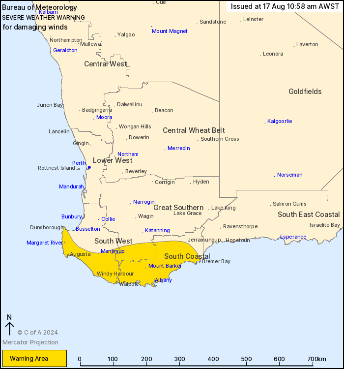
Source: Bureau of Meteorology
For people in South Coastal and parts of South West and Great
Southern districts.
Issued at 10:58 am Saturday, 17 August 2024.
Damaging winds are likely to develop about the southwest of the
state from early Sunday morning.
Weather Situation: A low pressure system is expected to strengthen
near the south coast overnight, causing a vigorous south to
southwesterly wind regime to develop during early Sunday morning.
The low is likely to initially be slow moving and remain near the
Albany coast during the morning, before moving to the east during
the afternoon and evening.
For EXPOSED COASTAL AREAS OF THE SOUTH WEST AND SOUTH COASTAL
DISTRICTS: South to southwesterly DAMAGING WINDS averaging 60 to 70
km/h with peak gusts to 100 km/h are likely to develop between Cape
Naturaliste and Albany from around midnight. These conditions may
possibly extend east to include the coastline between Albany and
Bremer Bay during the late morning.
For INLAND AREAS: Isolated DAMAGING WIND GUSTS reaching around 90
km/h are possible, developing around sunrise on Sunday and
continuing into the afternoon. As the low moves eastward during
Sunday afternoon and evening there is a possibility of DAMAGING
WIND GUSTS extending to areas of the South East Coastal
district.
Conditions are expected to ease from the west on Sunday evening
and then ease throughout the warning area during Monday morning as
the low pressure system weakens and moves into the Bight.
A separate Severe Weather Warning is current for heavy rainfall in
parts of the Southwest and Lower West districts during Saturday,
which is expected to ease during the early afternoon. Refer to
http://www.bom.gov.au/wa/warnings/ for more details.
Locations which may be affected include Albany, Margaret River,
Mount Barker, Bremer Bay, Dunsborough and Walpole.
The Department of Fire and Emergency Services advises that people
should:
* If outside find safe shelter away from trees, power lines, storm
water drains and streams.
* Close your curtains and blinds, and stay inside away from
windows.
* Unplug electrical appliances and do not use land line telephones
if there is lightning.
* If boating, swimming or surfing leave the water.
* Be alert and watch for hazards on the road such as fallen power
lines and loose debris.
* Keep away from flooded drains, rivers, streams and
waterways.
* Be careful of fallen trees, damaged buildings and debris.
* Be careful of fallen power lines. They are dangerous and should
always be treated as live.
* Assess your home, car and property for damage.
* If damage has occurred take photos and contact your insurance
company to organise permanent repairs.
* If your home or property has significant damage, like a badly
damaged roof or flooding, call the SES on 132 500.
17/Aug/2024 03:12 AM

