
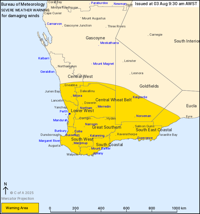
Source: Bureau of Meteorology
For people in Lower West, South West, South Coastal, South East
Coastal, Great Southern, Central Wheat Belt and parts of
Goldfields, Eucla, Central West and Gascoyne districts.
Issued at 9:30 am Sunday, 3 August 2025.
Damaging winds expected about the South West Land Division today,
contracting to the south coast this evening.
Weather Situation: A strong cold front has crossed the west coast
and will continue to sweep across the South West Land Division
today. The front will reach the southern Goldfields by
mid-afternoon before weakening as it approaches the western Eucla
by early evening. A strong southwesterly flow with gusty showers
and isolated thunderstorms will persist in the wake of the front
for much of Sunday before contracting to the southern coastal
fringe by early Monday morning.
DAMAGING WESTERLY WINDS averaging 55 to 65 km/h with peak gusts
around 100 km/h are expected across western and southern parts of
the South West Land Division, including the Perth metropolitan
area, today.
Strong westerly winds averaging 45 to 55 km/h with DAMAGING WIND
GUSTS around 90 km/h will extend to remaining inland and eastern
parts of the warning area in the middle of the day and will
continue throughout this afternoon, particularly in showers and
thunderstorms.
Winds will shift southwesterly over the western half of the South
West Land Division and ease below severe thresholds during late
Sunday afternoon. In the early evening, the risk of DAMAGING WINDS
will contract to the south coast and will then ease from the west
by early Monday morning.
People in the southwest of WA experience a front as windy as this
about 5 times per year.
A Coastal Hazard Warning is also current for parts of the west
coast. For more information see www.bom.gov.au/wa/warnings/
Locations which may be affected include Albany, Bunbury,
Esperance, Kalgoorlie, Katanning, Mandurah, Manjimup, Margaret
River, Merredin, Moora, Mount Barker, Narrogin, Norseman, Northam
and Perth.
104 km/h wind gust recorded at Garden Island at 7:19 am.
111 km/h wind gust recorded at Cape Leeuwin at 7:14 am.
91 km/h wind gust recorded at Colpoys Point at 5:41 am.
93 km/h wind gust recorded at Witchcliffe West at 4:43 am.
111 km/h wind gust recorded at Cape Naturaliste at 3:50 am.
100 km/h wind gust recorded at Rottnest Island Airport at 12:34
am.
The Department of Fire and Emergency Services advises that people
should:
* If outside find safe shelter away from trees, power lines, storm
water drains and streams.
* Close your curtains and blinds, and stay inside away from
windows.
* Unplug electrical appliances and do not use land line telephones
if there is lightning.
* If boating, swimming or surfing leave the water.
* Be alert and watch for hazards on the road such as fallen power
lines and loose debris.
* Keep away from flooded drains, rivers, streams and
waterways.
* Be careful of fallen trees, damaged buildings and debris.
* Be careful of fallen power lines. They are dangerous and should
always be treated as live.
* Assess your home, car and property for damage.
* If damage has occurred take photos and contact your insurance
company to organise permanent repairs.
* If your home or property has significant damage, like a badly
damaged roof or flooding, call the SES on 132 500.
03/Aug/2025 01:45 AM


