
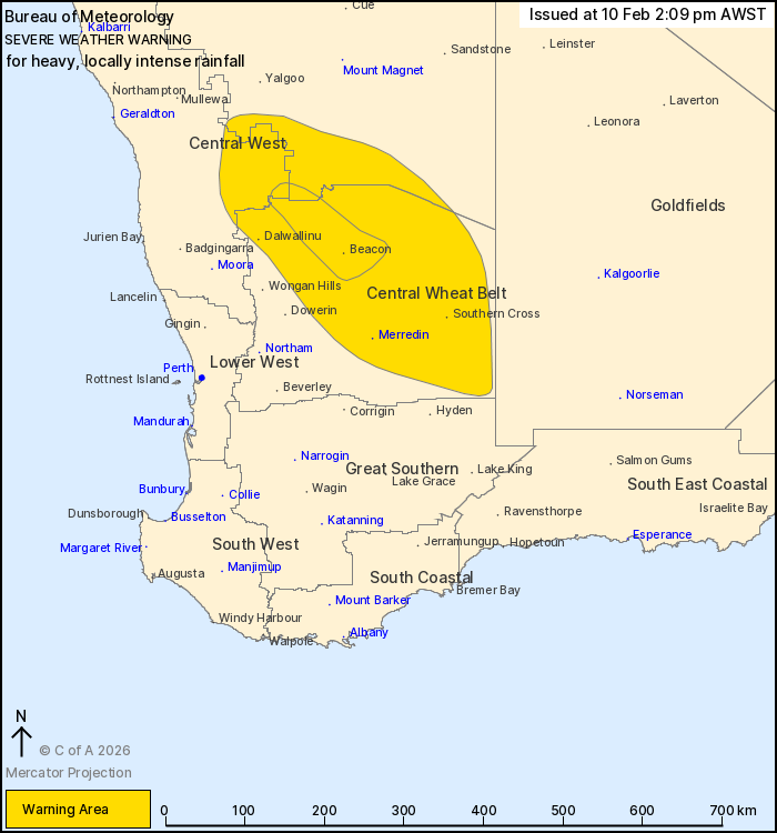
Source: Bureau of Meteorology
For people in Central Wheat Belt and parts of Central West and
Gascoyne districts.
Issued at 2:09 pm Tuesday, 10 February 2026.
HEAVY TO LOCALLY INTENSE RAINFALL AS EX-TROPICAL CYCLONE MITCHELL
TRACKS TO THE SOUTHEAST.
Weather Situation: Ex Tropical Cyclone Mitchell crossed the
Gascoyne coast early this morning and is continuing to track
southeast. Winds around the system have weakened, but heavy to
intense rainfall will persist today before easing late
tonight.
HEAVY RAINFALL which may lead to FLASH FLOODING is forecast for
parts of the Gascoyne, Central West and the Central Wheat Belt
today. Six-hourly rainfall totals between 25 and 50 mm are likely
with localised falls to 70 mm possible. 24-hour rainfall totals
between 50 and 80 mm are likely with localised totals to 120 mm
possible.
Locally INTENSE RAINFALL is possible on the southern side of the
low pressure system, including the area east of Dalwallinu,
including Beacon. Six-hourly rainfall totals up to 90 mm are
possible in this area.
This type of weather is unseasonable for people in the Central
West and Central Wheat Belt at this time of year.
Flood Watches and/or Warnings are current at the time of issue.
Please check
https://www.bom.gov.au/weather-and-climate/warnings-and-alerts/ for
more information.
Locations which may be affected include Merredin, Dalwallinu,
Southern Cross, Beacon, Paynes Find, Koolyanobbing and
Mukinbudin.
87.8 mm OF RAINFALL WAS RECORDED AT PINDARRING ROCKS IN 3 HOURS TO
09:00 AM.
69.2 mm of rainfall was recorded at Bullardoo in 6 hours to 09:00
am.
64.0 mm of rainfall was recorded at Greenough River (near Yuin
Station) in 6 hours to 09:00 am.
52.2 mm recorded at Canna East in the 6 hours to 12:25 pm.
48.0 mm of rainfall was recorded at Tallering in 6 hours to 09:00
am.
46.4 mm recorded at Perenjori Aero in the 6 hours to 01:00
pm.
40.2 mm recorded at Golden Grove in the 3 hours to 12:00 pm.
The Department of Fire and Emergency Services advises that people
should:
* If outside find safe shelter away from trees, power lines, storm
water drains and streams.
* Close your curtains and blinds, and stay inside away from
windows.
* Unplug electrical appliances and do not use land line telephones
if there is lightning.
* If boating, swimming or surfing leave the water.
* Be alert and watch for hazards on the road such as fallen power
lines and loose debris.
* Keep away from flooded drains, rivers, streams and
waterways.
* Be careful of fallen trees, damaged buildings and debris.
* Be careful of fallen power lines. They are dangerous and should
always be treated as live.
* Assess your home, car and property for damage.
* If damage has occurred take photos and contact your insurance
company to organise permanent repairs.
* If your home or property has significant damage, like a badly
damaged roof or flooding, call the SES on 132 500.
10/Feb/2026 06:33 AM


