
Source: Bureau of Meteorology
Issued at 5:41 am WST on Tuesday 24 March 2026
Headline:
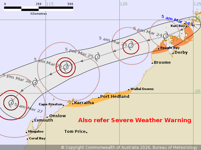
Ex-Tropical Cyclone Narelle is moving offshore of the west
Kimberley coast and is expected to redevelop into a tropical
cyclone during Tuesday night.
Areas Affected:
Warning Zone
Beagle Bay to Kuri Bay.
Watch Zone
Cape Preston to Wallal Downs, including Karratha and Port
Hedland.
Cancelled Zone
None.
Details of Ex-Tropical Cyclone Narelle 34U at 5:00 am AWST:
Intensity: Tropical Low, sustained winds near the centre of 55
kilometres per hour with wind gusts to 85 kilometres per
hour.
Location: within 55 kilometres of 15.3 degrees South 125.0 degrees
East, estimated to be 55 kilometres east northeast of Kuri Bay and
415 kilometres northeast of Broome.
Movement: west southwest at 25 kilometres per hour.
Ex-Tropical Cyclone Narelle is moving offshore of the west
Kimberley coast while heading west southwest. A Severe Weather
Warning is current in the area for damaging winds and possible
heavy rainfall.
The system will continue moving to the west southwest, roughly
parallel to the Pilbara coast during today and Wednesday. There is
a High chance that it redevelops into a tropical cyclone overnight
Tuesday, and it is forecast to reach severe (category 3) intensity
by Wednesday evening. While the system is likely to be over waters
well to the north of the Pilbara during Wednesday, gales may extend
south and over the Pilbara coast.
Longer term, the system is expected to begin turning to the
southeast and towards the WA coast late on Thursday or early on
Friday. The system is most likely to make landfall over the Central
West or Gascoyne coastlines, but may also impact the west Pilbara.
There is significant uncertainty as to exactly when are where the
system will cross the coast.
Hazards:
Isolated HEAVY RAINFALL which may lead to FLASH FLOODING may occur
across parts of the north Kimberley this morning.
GALES with DAMAGING WIND GUSTS to 90 km/h may develop along the
coast between Kuri Bay and Beagle Bay from later this morning.
Gales in this area are expected to then ease by Wednesday morning,
as the system moves further away from the west Kimberley
coast.
GALES with DAMAGING WIND GUSTS to 100 km/h may develop along the
coast between Wallal Downs and Port Hedland from Wednesday
afternoon, especially if the system takes a track further south.
Gales may extend further west to Cape Preston (including Karratha)
Wednesday night into Thursday morning.
Recommended Action:
DFES advises:
Ensure you know what to do in a cyclone. For the latest DFES
community alerts and warnings visit www.emergency.wa.gov.au or
download the Emergency WA app.
Current
Tropical Cyclones
23/Mar/2026 09:52 PM

