
Source: Bureau of Meteorology
Issued at 2:56 pm WST on Tuesday 11 February 2025
Headline:
Tropical low (18U) is forecast to develop into a tropical cyclone
early Wednesday before impacting the east Pilbara or west Kimberley
coast later this week.
Areas Affected:
Warning Zone
Broome to Port Hedland, including Port Hedland and not including
Broome.
Watch Zone
Port Hedland to Dampier and inland to Marble Bar including Marble
Bar
Cancelled Zone
Beagle Bay to Broome.
Details of Tropical Low 18U at 2:00 pm AWST:
Intensity: Tropical Low, sustained winds near the centre of 75
kilometres per hour with wind gusts to 100 kilometres per
hour.
Location: within 55 kilometres of 16.7 degrees South 119.6 degrees
East, estimated to be 315 kilometres west northwest of Broome and
415 kilometres north northeast of Port Hedland.
Movement: south southwest at 13 kilometres per hour.
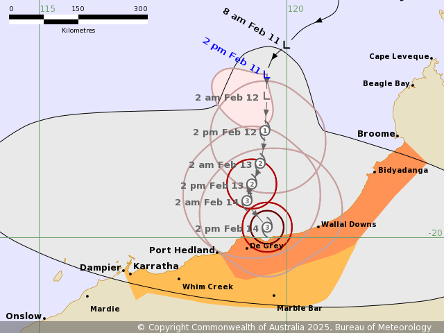
A tropical low (18U), currently located to the northwest of
Broome, is expected to move south and develop into a tropical
cyclone during Wednesday. The system is forecast to continue moving
south and intensify, possibly reaching Category 3 while still north
of the Pilbara coast. 18U may be slow moving during Thursday and
Friday before crossing the east Pilbara or west Kimberley coast as
a severe tropical cyclone later this week.
Hazards:
Gales with DAMAGING WIND GUSTS to 120 kilometres per hour may
develop along the coast between Broome (not including Broome) and
Port Hedland on Wednesday. These DAMAGING WIND GUSTS may extend
west to Dampier on Thursday if the system moves further west than
forecast.
DESTRUCTIVE WIND GUSTS of up to 160 kilometres per hour may
develop between Bidyadanga and Port Hedland during Thursday as 18U
moves closer to the coast.
Locally HEAVY RAINFALL may develop along the coast between Beagle
Bay and Port Hedland from Tuesday afternoon and continue Wednesday.
From Thursday, HEAVY to LOCALLY INTENSE RAINFALL which may lead to
FLASH FLOODING becomes likely along coastal parts between
Bidyadanga and Port Hedland, and extending to adjacent areas
inland. A Flood Watch is also current for catchments in the Pilbara
and western Kimberley.
Coastal residents between De Grey and Bidyadanga are specifically
warned of the dangerous storm tide as the cyclone crosses the
coast. The sea is likely to rise steadily up to a level well above
the normal tide, with damaging waves and flooding of some low-lying
areas close to the shoreline. People living in areas likely to be
affected by this flooding should take measures to protect their
property as much as possible and be prepared to follow instructions
regarding evacuation of the area if advised to do so by the
authorities.
Recommended Action:
Ensure you know what to do in a cyclone. For the latest DFES
community alerts and warnings visit www.emergency.wa.gov.au or
download the Emergency WA app.
Current
Tropical Cyclones
11/Feb/2025 07:15 AM

