
Source: Bureau of Meteorology
TROPICAL CYCLONE ADVICE NUMBER 53
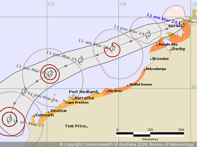
Issued at 11:55 am WST on Tuesday 24 March 2026
Headline:
Ex-Tropical Cyclone Narelle expected to redevelop into a tropical
cyclone tonight and move roughly parallel to the Pilbara coast on
Wednesday and Thursday. Gales possible from west of Bidyadanga on
Wednesday morning.
Areas Affected:
Warning Zone
Beagle Bay to Kuri Bay, and De Grey to Bidyadanga
Watch Zone
Exmouth to De Grey, including Exmouth, Onslow, Karratha and Port
Hedland.
Cancelled Zone
None.
Details of Ex-Tropical Cyclone Narelle 34U at 11:00 am AWST:
Intensity: Tropical Low, sustained winds near the centre of 65
kilometres per hour with wind gusts to 95 kilometres per
hour.
Location: within 35 kilometres of 15.4 degrees South 124.3 degrees
East, estimated to be 25 kilometres west northwest of Kuri Bay and
360 kilometres northeast of Broome.
Movement: west at 19 kilometres per hour.
Ex-Tropical Cyclone Narelle is moving offshore of the west
Kimberley coast and forecast to redevelop into a tropical cyclone
tonight.
Narelle will continue moving to the west southwest, roughly
parallel to the Pilbara coast during Wednesday and Thursday, and is
forecast to reach severe (category 3) intensity Wednesday night.
While Narelle is likely to be over waters well to the north of the
Pilbara during Wednesday and Thursday, gales may extend to the
Pilbara coast during this time.
On Friday Narelle is expected to turn south to southeast towards
the WA west coast with impacts expected as far south as the Lower
West on the weekend.
Hazards:
GALES with DAMAGING WIND GUSTS to 90 km/h may develop today along
the coast between Kuri Bay and Beagle Bay and gradually ease by
Wednesday morning, as the system moves further away from the west
Kimberley coast.
GALES with DAMAGING WIND GUSTS to 100 km/h may develop along the
coast between Bidyadanga and De Grey during Wednesday, especially
if the system takes a track further south. Gales are forecast to
extend further along the Pilbara coast during later Wednesday and
Thursday morning, possibly reaching Exmouth Thursday
afternoon.
Isolated HEAVY RAINFALL which may lead to FLASH FLOODING may occur
across parts of the north and west Kimberley today.
Tides will be higher than normal between Port Hedland and North
West Cape.
Recommended Action:
DFES advises:
Ensure you know what to do in a cyclone. For the latest DFES
community alerts and warnings visit www.emergency.wa.gov.au or
download the Emergency WA app.
Current
Tropical Cyclones
24/Mar/2026 04:10 AM

