
Source: Bureau of Meteorology
Issued at 0:57 am WST on Friday 27 March 2026
Headline:
Severe Tropical Cyclone Narelle, category 4, is currently
impacting the west Pilbara coast with severe impacts extending to
the Gascoyne coast Friday morning.
Areas Affected:
Warning Zone
Jurien Bay to Whim Creek, including Geraldton, Kalbarri, Denham,
Carnarvon, Exmouth, Onslow and Karratha.
Watch Zone
None.
Cancelled Zone
None.
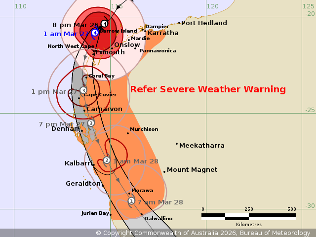
Details of Severe Tropical Cyclone Narelle 34U at 1:00 am
AWST:
Intensity: Category 4, sustained winds near the centre of 185
kilometres per hour with wind gusts to 260 kilometres per
hour.
Location: within 30 kilometres of 20.9 degrees South 114.2 degrees
East, estimated to be 125 kilometres northwest of Onslow and 115
kilometres north of Exmouth.
Movement: southwest at 19 kilometres per hour.
Severe Tropical Cyclone Narelle, category 4 is approaching the
North West Cape tonight.
Narelle located north of Exmouth and is turning to the south. It
is expect to pass close to the North West Cape as a category 4
cyclone during Friday morning. Severe impacts will extend from the
western Pilbara coast to the Gascoyne coast early morning Friday,
and then extending south to Carnarvon and Denham during
Friday.
Narelle is larger than usual and gales may still occur over the
central Pilbara coast. A Severe Weather Warning is also current for
damaging wind gusts east of Whim Creek and for inland parts of the
Pilbara.
On Saturday, Narelle is expected to be weakening as it moves
quickly to the south southeast, with impacts extending to the
Central West and then further inland and south across the South
West Land Division. During Saturday the strongest winds are
expected to be on the eastern side of the system.
Hazards:
VERY DESTRUCTIVE WIND GUSTS up to 275 km/h may develop between
Exmouth and Onslow overnight as Narelle moves closer to the North
West Cape, and then extend down the west coast to Cape Cuvier
during Friday morning. Carnarvon could see wind gusts up to 200
km/h Friday afternoon, and wind gusts up to 180 km/h could extend
to Denham late Friday or early Saturday.
DESTRUCTIVE WIND GUSTS in excess of 125 km/h are occurring along
the Pilbara coast between Mardie and the North West Cape, including
Exmouth and extend south along the Ningaloo coast early Friday
morning. DESTRUCTIVE WIND GUSTS in excess of 125 km/h are expected
to extend south to Carnarvon and then to Denham during Friday
morning and afternoon, and may extend to Kalbarri and inland parts
later on Friday and possibly as far south as Morawa Saturday
morning.
GALES with DAMAGING WIND GUSTS to 120 km/h are occurring near the
coast between Whim Creek and North West Cape, including Exmouth.
Gales will extend south Carnarvon and Denham Friday morning and
further south to Kalbarri and inland, possibly as far east as
Murchison, during Friday. Gales may extend south to Jurien Bay and
inland to Dalwallinu during Saturday morning.
HEAVY RAINFALL which may lead to FLASH FLOODING is possible in
western parts of the Pilbara and Gascoyne as Narelle moves past.
Areas of INTENSE RAINFALL that may lead to SEVERE FLASH FLOODING is
likely to develop about the western Pilbara west of about Onslow
overnight and Friday morning, before extending further south into
the northwestern Gascoyne later Friday morning.
Coastal residents between Onslow and Denham are specifically
warned of a DANGEROUS STORM TIDE as the cyclone moves south down
the Gascoyne coast. Tides are likely to rise significantly above
the normal high tide, with DAMAGING WAVES and DANGEROUS
FLOODING.
Tides will be higher than normal between Port Hedland and Onslow.
LARGE WAVES may produce MINOR FLOODING of low-lying coastal
areas.
Recommended Action:
DFES advises:
Ensure you know what to do in a cyclone. For the latest DFES
community alerts and warnings visit www.emergency.wa.gov.au or
download the Emergency WA app.
Current
Tropical Cyclones
26/Mar/2026 05:12 PM

