
Source: Bureau of Meteorology
Issued at 5:34 am WST on Tuesday 25 November 2025
Headline:
Tropical Cyclone Fina now category 2 as it continues to weaken
over land near the northeast Kimberley coast.
Areas Affected:
Warning Zone
King George River Mouth to Berkeley River Mouth.
Watch Zone
None.
Cancelled Zone
None.
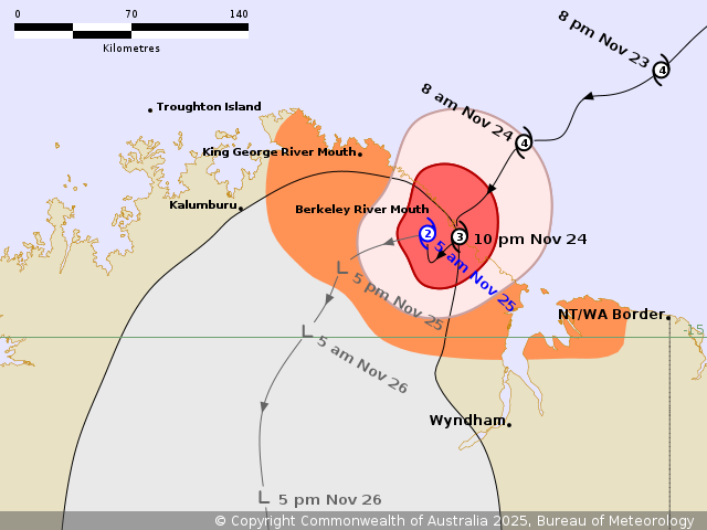
Details of Tropical Cyclone Fina 02U at 5:00 am AWST:
Intensity: Category 2, sustained winds near the centre of 100
kilometres per hour with wind gusts to 140 kilometres per
hour.
Location: within 20 kilometres of 14.4 degrees South 127.7 degrees
East, estimated to be 5 kilometres southwest of Berkeley River
Mouth and 110 kilometres east of Kalumburu.
Movement: slow moving.
Tropical Cyclone Fina crossed the coast at 9:30pm AWST Monday, and
is now slow moving just inland of the northeast Kimberley coast
near the Berkeley River Mouth. Fina is expected to weaken further
today while slowly moving inland.
Hazards:
DESTRUCTIVE WIND GUSTS to 155 km/h are occurring between King
George River Mouth and southeast of Berkeley River Mouth. These
conditions are expected to ease later this morning.
GALES with DAMAGING WIND GUSTS to 120 km/h are occurring along the
coast between King George River Mouth and the Cambridge Gulf, and
may extending to inland areas east of Kalumburu later today. These
conditions are expected to ease this afternoon as Fina moves
further inland and weakens.
HEAVY to LOCALLY INTENSE RAINFALL, which may lead to FLASH
FLOODING, is occurring about the northeast Kimberley coast and
adjacent inland.
Coastal residents between King George River Mouth and the WA/NT
Border may see tides rise above the normal high tide mark. LARGE
WAVES may produce MINOR FLOODING of low-lying coastal areas.
Recommended Action:
Western Australia DFES advises to ensure you know what to do in a
cyclone. For the latest DFES community alerts and warnings visit
www.emergency.wa.gov.au or download the Emergency WA app.
Current
Tropical Cyclones
24/Nov/2025 09:44 PM

