
Source: Bureau of Meteorology
Issued at 8:47 am WST on Friday 18 April 2025
Headline:
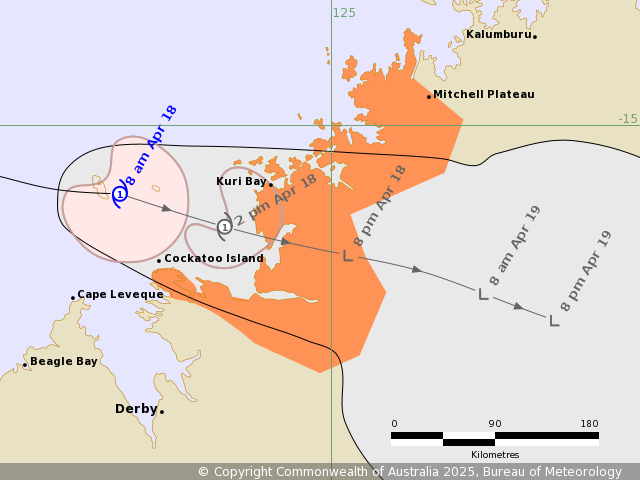
Tropical Cyclone Errol to cross the coast near Kuri Bay this
afternoon.
Areas Affected:
Warning Zone
Mitchell Plateau to Cockatoo Island.
Watch Zone
None.
Cancelled Zone
Beagle Bay to Cockatoo Island.
Details of Tropical Cyclone Errol 29U at 8:00 am AWST:
Intensity: Category 1, sustained winds near the centre of 65
kilometres per hour with wind gusts to 95 kilometres per
hour.
Location: within 30 kilometres of 15.6 degrees South 123.3 degrees
East, estimated to be 130 kilometres west of Kuri Bay and 200
kilometres north of Derby.
Movement: east at 21 kilometres per hour.
Tropical Cyclone Errol, a Category 1 cyclone, should weaken below
tropical cyclone strength today before crossing the west Kimberley
coast just to the south of Kuri Bay this afternoon. During
Saturday, the remnants of Errol are likely to be located over the
inland central Kimberley.
Rainfall is already occurring near Cape Leveque and Cockatoo
Island and is expected to increase and extend east and south ahead
of the centre crossing the coast.
Hazards:
Gales with DAMAGING WIND GUSTS to develop between Mitchell Plateau
and Cockatoo Island during Friday morning. There is a slight chance
of gales extending to just to the east of Kuri Bay if Errol tracks
closer to Kuri Bay during Friday afternoon.
HEAVY RAINFALL may occur between Mitchell Plateau and Derby on
Friday and persist into Saturday morning as Errol moves closer to
and crosses the west Kimberley coast.
Tides may rise above the normal high tide mark, but sea levels
should not exceed the highest tide of the year.
Recommended Action:
DFES advises: Ensure you know what to do in a cyclone. For the
latest DFES community alerts and warnings visit
www.emergency.wa.gov.au or download the Emergency WA app.
Current
Tropical Cyclones
18/Apr/2025 12:57 AM

