
Source: Bureau of Meteorology
TROPICAL CYCLONE ADVICE NUMBER 68
Issued at 8:51 am WST on Thursday 26 March 2026
Headline:
Severe Tropical Cyclone Narelle steadily intensifying. Severe
impacts possible for the west Pilbara and Gascoyne coasts .
Areas Affected:
Warning Zone
Pardoo Roadhouse to Carnarvon, including Port Hedland, Karratha,
Onslow, Exmouth, and Coral Bay, and extending inland to
Pannawonica.
Watch Zone
South of Carnarvon to Jurien Bay, including Denham and Geraldton,
and extending inland to Gascoyne Junction, Murchison, Morawa and
Yalgoo.
Cancelled Zone
None.
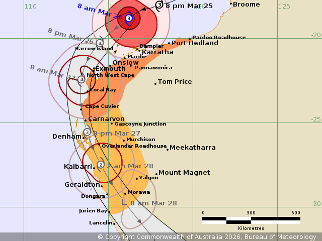
Details of Severe Tropical Cyclone Narelle 34U at 8:00 am
AWST:
Intensity: Category 3, sustained winds near the centre of 155
kilometres per hour with wind gusts to 220 kilometres per
hour.
Location: within 35 kilometres of 18.8 degrees South 116.2 degrees
East, estimated to be 225 kilometres north northwest of Karratha
and 410 kilometres north northeast of Exmouth.
Movement: west southwest at 17 kilometres per hour.
Severe Tropical Cyclone Narelle is a category 3 tropical cyclone
and is expected to continue to strengthen.
Narelle is moving west southwest, roughly parallel to the Pilbara
coast. Narelle is larger than usual and although the cyclone is
located well north of the Pilbara, gales extend to the coast.
On Friday, Narelle will turn towards the south, likely passing
close to the North West Cape as a category 4 cyclone.
There is the potential for a severe impact on the far western
Pilbara coast from later Thursday, extending south to Denham during
Friday.
On Saturday Narelle is expected to be weakening as it moves
quickly to the south southeast with impacts extending to the
Central West and then further inland and south across the South
West Land Division. During Saturday the strongest winds are
expected to be on the eastern side of the system.
Hazards:
VERY DESTRUCTIVE WIND GUSTS up to 275 km/h may develop between
Exmouth and Onslow later on Thursday as Narelle moves closer to the
North West Cape, and then extend down the west coast to Cape Cuvier
during Friday morning. Carnarvon could see wind gusts up to 220
km/h during Friday, and wind gusts up to 195 km/h could extend to
Denham late Friday or early Saturday.
DESTRUCTIVE WIND GUSTS in excess of 125 km/h may occur on the
Pilbara coast near Karratha during Thursday morning, extending west
to Exmouth during Thursday, and south to Carnarvon and then to
Denham and the Overlander Roadhouse during Friday.
GALES with DAMAGING WIND GUSTS to 120 km/h are occurring just
offshore and will occasionally extend to the near coastal parts
between Pardoo Roadhouse and Mardie, including Port Hedland and
Karratha. Gales will develop west to Exmouth during Thursday and
extend further south to Kalbarri and inland to the Overlander
Roadhouse and possibly to Murchison during Friday. Gales may extend
south to Jurien Bay and inland to Morawa during Saturday
morning.
HEAVY RAINFALL which may lead to FLASH FLOODING is possible in
western parts of the Pilbara and Gascoyne as Narelle moves
past.
Coastal residents between Onslow and Denham are specifically
warned of a DANGEROUS STORM TIDE as the cyclone moves south down
the Gascoyne coast. Tides are likely to rise significantly above
the normal high tide, with DAMAGING WAVES and DANGEROUS
FLOODING.
Tides will be higher than normal between Port Hedland and Onslow.
LARGE WAVES may produce MINOR FLOODING of low-lying coastal
areas.
Current
Tropical Cyclones
26/Mar/2026 01:00 AM

