
Source: Bureau of Meteorology
Issued at 5:58 pm WST on Friday 14 February 2025
Headline:
Severe Tropical Cyclone Zelia now moving to the south over the
inland eastern Pilbara and there is the risk of destructive winds
at Marble Bar this evening.
Areas Affected:
Warning Zone
Port Hedland to Pardoo Roadhouse not including Port Hedland or
Pardoo, extending inland to Marble Bar, Nullagine, and Munjina
.
Watch Zone
None.
Cancelled Zone
Coastal zone between Whim Creek and Port Hedland, and coastal zone
between Pardoo Roadhouse and Wallal Downs. .
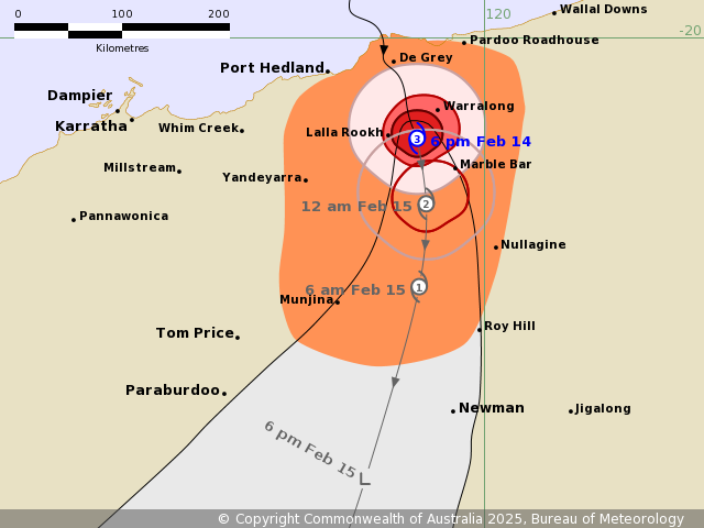
Details of Severe Tropical Cyclone Zelia 18U at 6:00 pm
AWST:
Intensity: Category 3, sustained winds near the centre of 140
kilometres per hour with wind gusts to 195 kilometres per
hour.
Location: within 20 kilometres of 20.9 degrees South 119.4 degrees
East, estimated to be 105 kilometres southeast of Port Hedland and
50 kilometres northwest of Marble Bar.
Movement: south southeast at 19 kilometres per hour.
Severe Tropical Cyclone Zelia made landfall at 12:30pm near De
Grey River mouth, northeast of Port Hedland at category 4
intensity. Zelia will now take a general southerly track over land
and weaken. Intense rainfall is expected near and to the east of
the centre of the cyclone.
Hazards:
VERY DESTRUCTIVE WIND GUSTS of up to 200 kilometres per hour are
likely within 30 kilometres of the centre of the cyclone until late
this evening.
DESTRUCTIVE WIND GUSTS of up to 160 kilometres per hour are
occurring over areas within 50 kilometres of the centre of the
cyclone, these winds may impact Marble Bar for a period from about
8 pm this evening.
Gales with DAMAGING WIND GUSTS to 120 kilometres per hour are
occurring coastal areas between Pardoo and Port Hedland and are
expected to ease this evening. DAMAGING WIND GUSTS to 120
kilometres per hour are also occurring inland to Marble Bar, and
will possibly extend to Nullagine and Munjina Saturday
morning.
HEAVY to LOCALLY INTENSE RAINFALL which may lead to FLASH FLOODING
is occurring across coastal and adjacent inland areas between
Wallal Downs and Whim Creek, extending inland to Marble Bar and
Nullagine overnight. A Severe Weather Warning has been issued for
the southeast Pilbara and northeast Gascoyne for the risk of
damaging winds gusts and heavy rainfall after Zelia weakens below
tropical cyclone intensity. Flood Watches and Warnings are also
current for catchments in the Pilbara, western Kimberley and
northern Gascoyne. Go to www.bom.gov.au/wa/warnings for further
details.
There is no longer a risk of a large storm tide at Port Hedland or
areas to the east however tides may rise higher than the highest
astronomical tide on the high tide overnight.
Recommended Action:
Ensure you know what to do in a cyclone. For the latest DFES
community alerts and warnings visit www.emergency.wa.gov.au or
download the Emergency WA app.
Current
Tropical Cyclones
14/Feb/2025 10:55 AM

