
Source: Bureau of Meteorology
Issued at 5:43 am WST on Friday 28 March 2025
Headline:
Tropical Cyclone risk for the northwest Kimberley coast, between
Troughton Island and Beagle Bay.
Areas Affected:
Warning Zone
Troughton Island to Beagle Bay, including Derby.
Watch Zone
None.
Cancelled Zone
None.
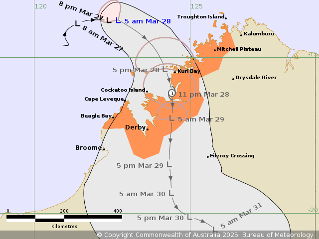
Details of Tropical Low 28U at 5:00 am AWST:
Intensity: Tropical Low, sustained winds near the centre of 65
kilometres per hour with wind gusts to 95 kilometres per
hour.
Location: within 65 kilometres of 13.8 degrees South 122.7 degrees
East, estimated to be 270 kilometres northwest of Kuri Bay and 405
kilometres north northwest of Derby.
Movement: slow moving.
Tropical low 28U is developing to the northwest of the Kimberley.
It is currently moving to the east and expected to turn to the
south southeast during today. It is forecast to reach tropical
cyclone intensity before crossing the Kimberley coast tonight or
Saturday morning, most likely northeast of Derby between Kuri Bay
and Cape Leveque. Later Saturday and during Sunday 28U is likely to
be weakening over land.
Hazards:
Gales with DAMAGING WIND GUSTS to 100 kilometres per hour likely
to develop in coastal areas between Mitchell Plateau and Beagle Bay
during this evening and Saturday morning. Gales are less likely at
Derby, the highest risk period being during Saturday. Gales may
extend east to Truscott Island on Friday evening if the system
takes a track further east.
HEAVY RAINFALL which may lead to FLASH FLOODING is possible in
parts of the northern and western Kimberley from Friday, extending
further inland during the weekend.
As the system approaches and crosses the coast tides between Derby
and Troughton Island may rise above the normal high tide mark, but
the sea level should not exceed the highest tide of the year.
Recommended Action:
Ensure you know what to do in a cyclone. For the latest DFES
community alerts and warnings visit www.emergency.wa.gov.au or
download the Emergency WA app.
Current
Tropical Cyclones
27/Mar/2025 10:01 PM

