
Source: Bureau of Meteorology
Issued at 10:57 am WST on Friday 14 February 2025
Headline:
Severe Tropical Cyclone Zelia to make landfall just east of Port
Hedland this afternoon.
Areas Affected:
Warning Zone
Wallal Downs to Roebourne, including Port Hedland, and extending
inland to Marble Bar, Millstream, Nullagine, Tom Price and
Paraburdoo but not including Roebourne.
Watch Zone
None.
Cancelled Zone
None.
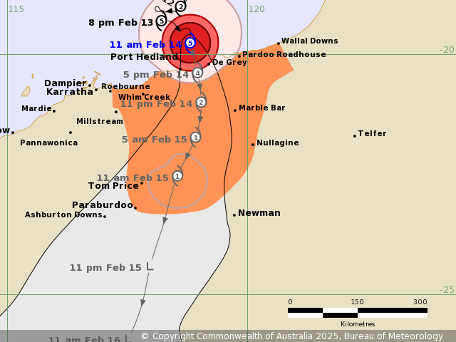
Details of Severe Tropical Cyclone Zelia 18U at 11:00 am
AWST:
Intensity: Category 5, sustained winds near the centre of 205
kilometres per hour with wind gusts to 285 kilometres per
hour.
Location: within 20 kilometres of 19.8 degrees South 118.8 degrees
East, estimated to be 65 kilometres north northeast of Port Hedland
and 185 kilometres north northwest of Marble Bar.
Movement: southeast at 8 kilometres per hour.
Severe Tropical Cyclone Zelia (category 5) is moving to the south
southeast and expected to make landfall this afternoon just to the
east of Port Hedland. Zelia will then take a general southerly
track overland and gradually weaken. Intense rainfall is expected
near and to the east of the centre of the cyclone as it crosses the
coast.
Hazards:
VERY DESTRUCTIVE WIND GUSTS of up to 290 kilometres per hour are
likely close to the centre of the cyclone as it crosses the coast
later this afternoon.
DESTRUCTIVE WIND GUSTS of up to 160 kilometres per hour are likely
to develop in coastal areas east of Whim Creek to De Grey,
including Port Hedland by early afternoon.
Gales with DAMAGING WIND GUSTS to 120 kilometres per hour are
occurring on the coast between Pardoo and Whim Creek, including
Port Hedland. Gales with gusts to 90 kilometres per hour may extend
to other areas along the coast between Wallal Downs and east of
Roebourne, if the track deviates from forecast. DAMAGING WIND GUSTS
to 120 kilometres per hour may also extend to inland areas,
possibly including Marble Bar, Nullagine, or Tom Price and
Paraburdoo, from early Saturday.
HEAVY to LOCALLY INTENSE RAINFALL which may lead to FLASH FLOODING
is likely today across coastal and adjacent inland areas between
Wallal Downs and Whim Creek, extending inland to Nullagine and Tom
Price by early Saturday. A Flood Watches and Warnings are also
current for catchments in the Pilbara, western Kimberley and
northern Gascoyne. Go to www.bom.gov.au/wa/warnings for further
details.
Residents in Port Hedland and east to Wallal Downs are
specifically warned of the potential of a DANGEROUS STORM TIDE as
the cyclone centre crosses the coast. However, the more recent
motion to the southeast decreases the risk of the storm tide at
Port Hedland for the noon high today. Tides are likely to rise
significantly above the normal high tide mark with damaging waves
and dangerous flooding of some low-lying areas close to the
shoreline.
Recommended Action:
Ensure you know what to do in a cyclone. For the latest DFES
community alerts and warnings visit www.emergency.wa.gov.au or
download the Emergency WA app.
Current
Tropical Cyclones
14/Feb/2025 03:11 AM

