
Source: Bureau of Meteorology
ROPICAL CYCLONE ADVICE NUMBER 38
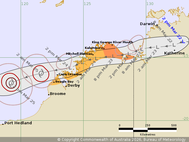
Issued at 2:43 pm WST on Sunday 22 March 2026
Headline:
Ex-Tropical Cyclone Narelle moving west across the NT, likely to
redevelop off the west Kimberley coast early this week.
Areas Affected:
Warning Zone
Kalumburu to the WA/NT Border.
Watch Zone
Beagle Bay to west of Kalumburu.
Cancelled Zone
None.
Details of Ex-Tropical Cyclone Narelle 34U at 2:00 pm AWST:
Intensity: Tropical Low, sustained winds near the centre of 55
kilometres per hour with wind gusts to 85 kilometres per
hour.
Location: within 45 kilometres of 13.7 degrees South 133.0 degrees
East, estimated to be 115 kilometres northeast of Katherine and 560
kilometres east northeast of Wyndham.
Movement: west at 24 kilometres per hour.
Ex-Tropical Cyclone Narelle will continue tracking west across the
Top End on Sunday as a well defined tropical low. A Severe Weather
Warning is current for heavy, locally intense rainfall and damaging
wind gusts affecting the NT.
During Monday the low is expected to move over the Joseph
Bonaparte Gulf and gales may redevelop to the north of the centre.
These gales may impact the northeast Kimberley coast, however there
is only a low chance of the system redeveloping into a tropical
cyclone at this time. The passage of the low across the north
Kimberley is likely to be accompanied by heavy rainfall.
During Tuesday Ex-Tropical Cyclone Narelle is forecast to move
offshore of the west Kimberely coast and has a high chance of
redeveloping into a tropical cyclone with a risk of coastal gales
between Beagle Bay and west of Kalumburu. It is likely to be
located to the north of the Pilbara coast and moving west southwest
by mid-week.
Hazards:
HEAVY RAINFALL which may lead to FLASH FLOODING is likely to
develop across the north Kimberley during Monday.
GALES with DAMAGING WIND GUSTS to 90 km/h may develop along the
coast between Kalumburu and the WA/NT border during Monday as the
low moves west.
GALES with DAMAGING WIND GUSTS to 100 km/h may develop along the
coast between Beagle Bay and west of Kalumburu during
Tuesday.
Recommended Action:
DFES advises:
Ensure you know what to do in a cyclone. For the latest DFES
community alerts and warnings visit www.emergency.wa.gov.au or
download the Emergency WA app.
Current
Tropical Cyclones
22/Mar/2026 07:08 AM

