
Source: Bureau of Meteorology
Issued at 2:47 am WST on Tuesday 11 February 2025
Headline:
Tropical low (18U) off the northwest Kimberley developing slowing
and moving southwest.
Areas Affected:
Warning Zone
None.
Watch Zone
Cape Leveque to Port Hedland, including Broome.
Cancelled Zone
None.
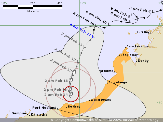
Details of Tropical Low 18U at 2:00 am AWST:
Intensity: Tropical Low, sustained winds near the centre of 45
kilometres per hour with wind gusts to 85 kilometres per
hour.
Location: within 75 kilometres of 15.7 degrees South 120.9 degrees
East, estimated to be 290 kilometres north northwest of Broome and
230 kilometres west northwest of Cape Leveque.
Movement: southwest at 9 kilometres per hour.
A tropical low (18U) to the northwest of the Kimberley coast is
expected to move south and slowly develop over the next few days.
It is expected to approach the coast as a significant system later
in the week. There is high uncertainty regarding its forecast
intensity and track from mid-week.
Hazards:
Gales with DAMAGING WIND GUSTS to 100 kilometres per hour may
develop along the coast between Cape Leveque and Port Hedland
during Wednesday or Thursday.
Locally heavy falls may develop along the coast between Cape
Leveque and Port Hedland during Wednesday or Thursday. The slow
movement of the system as it approaches the coast may result in
very high falls near the track. Refer to Flood Watch for further
information.
Abnormally high tides are possible between Cape Leveque and Port
Hedland on Wednesday but sea levels should not exceed the highest
tide of the year. Higher tides may occur as the system nears the
coast.
Current
Tropical Cyclones
10/Feb/2025 08:00 PM

