
Source: Bureau of Meteorology
Issued at 7:26 am ACST [5:56 am AWST] on Sunday 23 November
2025
Headline:
Severe Tropical Cyclone Fina is located to the west of Darwin and
slowly moving away from the coast.
Areas Affected:
Warning Zone
The central and western Tiwi Islands and Cape Hotham to Wadeye.
This includes Darwin, Pirlangimpi, Milikapiti, Wurrumiyanga and
Wadeye.
Watch Zone
Wadeye (NT) to Troughton Island (WA) including Kalumburu
(WA).
Cancelled Zone
None.
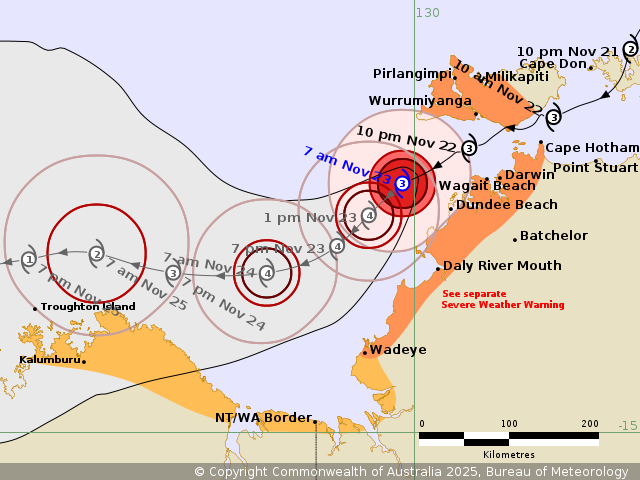
Details of Severe Tropical Cyclone Fina 02U at 6:30 am ACST [5:00
am AWST]:
Intensity: Category 3, sustained winds near the centre of 150
kilometres per hour with wind gusts to 205 kilometres per
hour.
Location: within 20 kilometres of 12.5 degrees South 129.9 degrees
East, estimated to be 110 kilometres west of Darwin and 115
kilometres southwest of Wurrumiyanga.
Movement: west southwest at 10 kilometres per hour.
Fina remains as a small but intense category 3 cyclone. It is
slowly moving southwest, away from Darwin. The very destructive
core of the cyclone is now located well off the northwest Top End
coast.
Fina is forecast to remain a severe tropical cyclone during Sunday
as it moves southwest, through the southern Timor Sea. It will
start weakening during Monday as it nears the north of the
Kimberley coast.
Hazards:
VERY DESTRUCTIVE WIND GUSTS to 185 km/h are no longer expected
over mainland or island areas as Fina continues to move away from
the coast.
DESTRUCTIVE WIND GUSTS to 155 km/h are possible about the exposed
coastal areas of the Cox Peninsula, including Dundee Beach for the
next few hours. Destructive wind gusts are no longer expected over
the Tiwi islands, including Wurrumiyanga.
GALES with DAMAGING WIND GUSTS to 120 km/h are likely about the
coastal areas southwest of Darwin to Daly River Mouth. Gales may
further extend from Daly River Mouth to Wadeye later today, only if
Fina takes a more southerly track.
DAMAGING WIND GUSTS to 120 km/h are still possible about the Tiwi
Islands and coastal areas from Darwin to Cape Hotham within the
warning zone during the morning.
GALES may possibly extend to coastal parts of the north Kimberley
in WA on Monday, from Kalumburu to the WA/NT Border, as Fina moves
through the Timor Sea and begins to weaken. Gales are not expected
to extend to Wyndham or Kununurra.
HEAVY to LOCALLY INTENSE RAINFALL, which may lead to FLASH
FLOODING, is expected to continue around Darwin, and adjacent
inland areas during the morning, extending southwest to Daly River
Mouth. Refer to the adjacent Severe Weather Warning.
Coastal residents on the Tiwi Islands, and between Cape Hotham and
Warruwi are specifically warned that tides may continue to rise
above the normal high tide mark with LARGE WAVES and MINOR FLOODING
of low-lying coastal areas.
Recommended Action:
NTES advises people about coastal locations around the Cox
Peninsula, should stay calm and remain in a secure shelter. Do not
venture outside. Heed the advice and follow the instructions of
Emergency Services personnel and local authorities.
NTES advises people about the central and western Tiwi Islands,
and areas between Daly River Mouth to Cape Hotham, including
Darwin, should remain sheltered in a safe place. Outside property,
including boats, playground equipment, chairs and tables should be
secured.
NTES advises people between Daly River Mouth and Wadeye should
immediately commence or continue preparations, especially securing
boats and property, using available daylight hours.
NTES advises people elsewhere near and between Wadeye and the
NT/WA Border should consider what action they will need to take if
the cyclone threat increases. For cyclone preparedness and safety
advice, visit the Secure NT website (https://securent.nt.gov.au).
For emergency assistance call the Northern Territory Emergency
Service (NTES) on 132 500 (for assistance with storm damage, rising
flood water, fallen trees on buildings or roof damage).
Current
Tropical Cyclones
22/Nov/2025 10:14 PM

