
Source: Bureau of Meteorology
Issued at 1:28 pm EDT on Thursday 6 March 2025
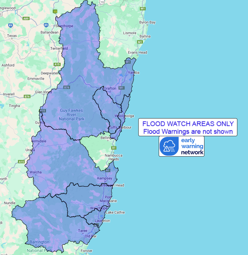
Flood Watch Number: 5
MAJOR RIVERINE FLOODING WITH SIGNIFICANT LOCALISED FLOODING
POSSIBLE ALONG THE NORTHERN RIVERS AND MID NORTH COAST FROM LATER
THURSDAY INTO THE WEEKEND
Rainfall associated with Tropical Cyclone Alfred is likely to
cause rapid and dangerous river rises and extensive flooding along
NSW coastal rivers from the Queensland border to Port Macquarie
from later Thursday through to the weekend.
The location of the heaviest rainfall and most severe flooding
will depend on the track of Tropical Cyclone Alfred. Heavy and
locally intense rainfall is forecast to increase Thursday night and
into the weekend over Northern NSW. The heaviest rainfall will be
south of the Tropical Cyclone track.
Heavy rainfall has fallen across the Northern Rivers and Mid North
Coast. Catchments in these districts are becoming wet to
saturated.
Moderate to major flooding may develop from later Thursday in the
Flood Watch area. Flash flooding is possible. High tides and large
waves are expected to increase the flood risk and impacts in low
lying coastal areas. Areas at risk will continue to be revised
during the coming days.
Flood Classes (minor, moderate, major) are only defined for
catchments where the Bureau provides a flood warning service.
Catchments likely to be affected include:
Clarence River
moderate to major flooding
Orara River
moderate to major flooding
Coffs Coast
Macleay River
moderate to major flooding
Hastings River
moderate to major flooding
Camden Haven River
moderate to major flooding
Manning and Gloucester Rivers
minor flooding
A flood warning is current for the Tweed, Brunswick, Wilsons,
Richmond, Bellinger, Kalang and Nambucca Rivers.
For the latest flood and weather warnings see
www.bom.gov.au/nsw/warnings/
For the latest rainfall and weather forecasts see
www.bom.gov.au/australia/meteye/
For the latest rainfall and river level information see
www.bom.gov.au/nsw/flood
Flood Safety Advice:
This Flood Watch means that people living or working along rivers
and streams must monitor the latest weather forecasts and warnings
and be ready to move to higher ground should flooding
develop.
Flood Warnings will be issued if Minor Flood Level is expected to
be exceeded at key sites along the main rivers for which the Bureau
of Meteorology provides a flood warning service.
Severe Weather Warnings will be issued or updated if very heavy
rain is forecast or observed.
For more information on the Flood Watch Service:
http://www.bom.gov.au/water/floods/floodWarningServices.shtml
FloodSafe advice is available at www.ses.nsw.gov.au
For emergency assistance call the SES on telephone number 132
500
For life threatening emergencies, call 000 immediately
Rainfall and River
Conditions Map
06/Mar/2025 02:43 AM

